|
Home >
Settings >
Archives >
March 2021 >
ASEAN Geospatial Challenge 2021 Winners
ASEAN Geospatial Challenge 2021 Winners
Teams from ASEAN institutes of higher learning clinched awards at the first ASEAN Geospatial Challenge 2021 (Youth Edition). Announced at Geo Connect Asia on 24 March, the winners set themselves a challenge to use their geospatial skills to help nations achieve their sustainable development goals. Supported by geospatial agencies from Brunei (The Ministry of Development, Survey Department), Myanmar (The Ministry of Natural Resources and Environmental Conservation, Survey Department), The Philippines (The National Mapping and Resource Information Authority), Singapore (Singapore Land Authority) and Viet Nam (The Ministry of Natural Resources and Environment, Department of Survey, Mapping and Geographic Information), the challenge received 27 entries.
The Distinction Award went to:
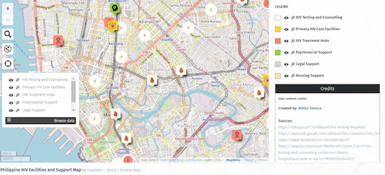
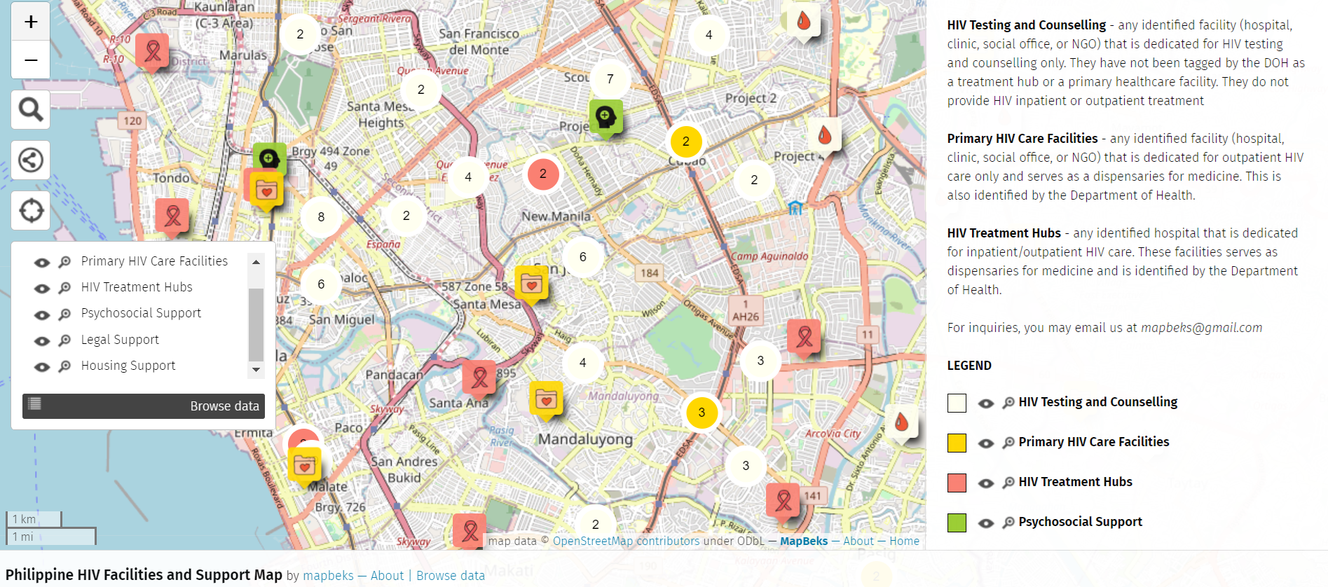
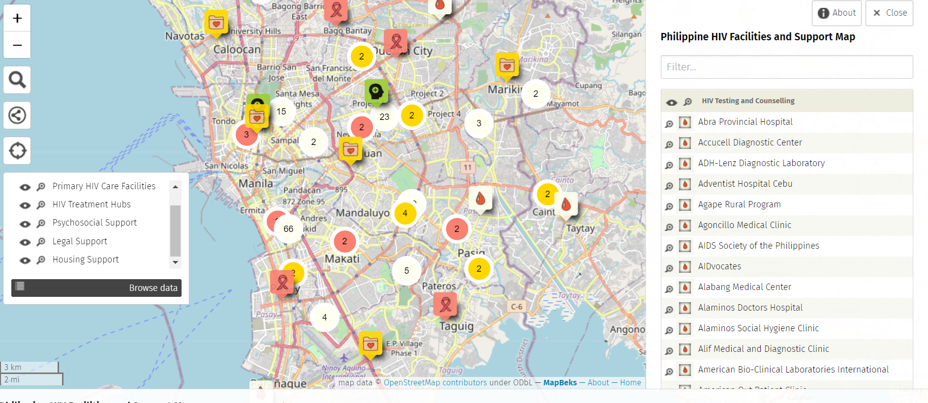
Team: MapBeks from UP Diliman and Polytechnic University of the Philippines - San Juan (Philippines)

Project:
MapBeks’ HIV and Support Facilities Mapping project aims to augment the country’s HIV and AIDS programme by creating an up-to-date, validated map consolidating all government and private facilities that offer HIV services.
The Excellence Awards went to the following teams. The teams are not listed in any order of preference:
Team: SusCo Tech from SUTD (Singapore)
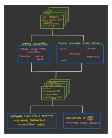
Project:
SusCo Tech’s solution tackles the challenges of harnessing renewable energy in different communities, defined by geographical zones.
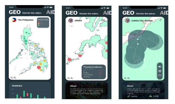
Team: GEO-AID from University of the Philippines Los Baños (Philippines)
Project:
Project GEO-AID is a Geospatial Database Crowdfunding Application Development that aims to address the first Sustainable Development Goal - to end poverty and all its forms everywhere - using an interactive map system.
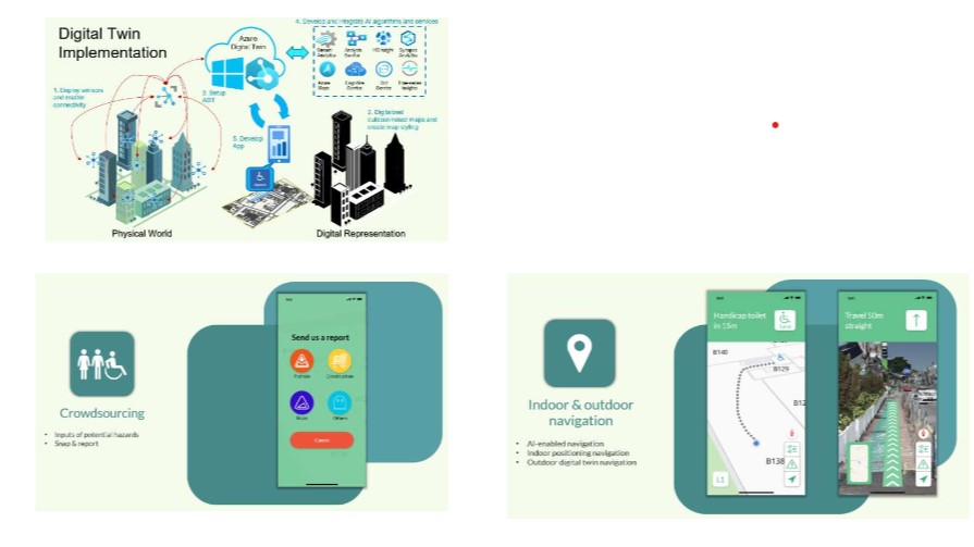
Team: SYT2 from SMU, SIT, SIM and SUSS (Singapore)
Project:
Team SYT2 is a collaboration between students from four Institutes of Higher Learning - SMU, SIT, SIM and SUSS. Their project aims to empower wheelchair users to live independently and confidently and is aligned with SDG11 to foster the integration of an inclusive society within cities and communities.
Judges Prof Andrew Hudson-Smith from University College London and Dr Sanghoon Lee from the Ministry of Environment in the Republic of Korea were impressed with the entries received.
“Amazing work. And they've looked at the problem first and then see how geospatial technology can solve that. They're excellent, innovative, forward thinking. And to be honest, it gives me hope in the future of geospatial,” said Prof Hudson-Smith.
“In the future, developing geospatial information needs not only location-based technology, but also to interpret geo context and geo knowledge for solving real world problem(s) in a more intelligent way,” Dr Lee added.
We thank all our judges for their time and effort in assessing all the projects.
National Level (Singapore) Judges
- Mark Yong
Garuda Robotics
Co-Founder & CEO - Ng Siau Yong
Singapore Land Authority
Director and Chief Data Officer, Geospatial & Data Division - Dr Parry Oei
Maritime and Port Authority of Singapore
Adviser (Hydrography) - Sriram Iyer
Grab
Head of Product Geo - Thomas Pramotedham
Esri Singapore
Chief Executive Officer
ASEAN Level Judges
- Prof. Andrew Hudson-Smith
University College London
Professor (Digital Urban Systems at The Bartlett Centre for Advanced Spatial Analysis) - Dr Joshua Lieberman
Open Geospatial Consortium
Director (Innovation Programs) - Prof Min Chen
Nanjing Normal University, China - Dr Sanghoon Lee
Ministry of Environment, Republic of Korea
Deputy Director (Water Resources Policy Division) - Taro Ubukawa
We thank all our partners for their support in making the ASEAN Geospatial Challenge 21 a success!