
|
Home >
Settings >
Archives >
December 2021 >
Meet a GeoPartner: Phase One
Meet a GeoPartner: Phase One
Welcome Phase One, our new GeoPartner!

Michael Fu
We spoke to Michael Fu, Business Development Director, SEA, Digitalisation & Geospatial at Phase One about his company’s products, solutions and the role of geospatial technology in their work.
1. Tell us about your company and its solutions.
Phase One A/S is a leading researcher, developer and manufacturer of medium format and large format digital cameras, software and imaging solutions.
Founded in 1993, Phase One is a pioneer in digital photography. Phase One has developed core imaging technologies and a range of digital cameras and imaging modules. Phase One provides the world’s highest image quality in terms of resolution, dynamic range, color fidelity and geometric accuracy. As such, Phase One has grown to become the leading provider of high-end imaging technology across many business segments. This includes both hardware and software for aerial mapping, industrial inspection and cultural heritage digitization, as well as serving the world’s most demanding photographers.
Based in Copenhagen, Denmark, and with regional offices in New York, Denver, Cologne, Tel Aviv, Tokyo, Beijing, Shanghai and Hong Kong, Phase One nurtures long-term relationships with customers, technology partners and its global network of distributors, often playing the role of digital imaging partner to customers with special requirements. It is with this passion for service that Phase One continually exceeds expectations and drives the imaging industry forward.
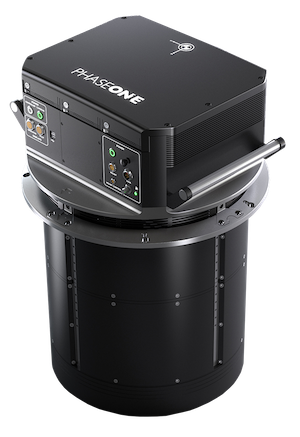
Phase One unveiled the PAS 880 fully integrated large-format nadir and oblique camera system for aerial mapping in December 2020. The PAS 880 integrates a 280-megapixel (MP) nadir camera with four oblique 150 MP cameras into a single pod to simultaneously capture photogrammetric 2D and 3D digital imagery.
2. What is something about your company that the general public might not know about?
Phase One not only specialises in geospatial solutions but is also very established in the bespoke photography and cultural preservation industries.
Many of the reputable fashion and landscape photographers use Phase One cameras (https://photography.phaseone.com/ and https://digitization.phaseone.com/).
3. What are some challenges you have faced in your work?
I can’t really comment as I’m only three months into the job!
4. How has your experience with GeoWorks been?
It has been awesome so far. The team has been very responsive and supportive towards my enquiries, easing me into the geospatial community within Singapore.
5. How does geospatial technology help you in your work?
We believe that with a medium format sensor (up to 880MP resolution), it is possible to drive productivity for aerial and survey mapping yet without losing the smallest of details.
A good example would be our newly launched P3 payload which can be easily fitted onto a VTOL. Inspection applications using the P3 can be done significantly faster (as each image covers a larger area) while ensuring that small defects are not being missed out.
6. Are there any challenges that come with working with geospatial technology?
One of the biggest challenges is the fact that there is a lack of specified knowledge in the geospatial field since the majority of people who are involved in this field either come from different backgrounds or they focus their knowledge on only one part of the geospatial industry, lack of accuracy standards in some fields. There are recommendations but standards are missing. Another challenge is keeping track with the very fast innovation in various technologies.
7. In your opinion, what skills are needed to work in the geospatial industry?
The most important skill required is a willingness to adopt to new technologies. A background in Geodetics is a great bonus and helps to develop a clear focus on specific customer requirements.
8. Do you have any advice for aspiring entrepreneurs?
Always try to listen and learn more about different technologies. There is not a single or perfect one size fits all solution in the geospatial industry. Being innovative, thinking outside the box and looking for best practices and ideas in neighbouring specialisms is a great bonus and is required to solve new challenges.