
|
Home >
Settings >
Archives >
August 2021 >
Meet a GeoWorks’ GeoTech: NextBillion.ai
Meet a GeoWorks’ GeoTech: NextBillion.ai
In this “Meet a GeoWorks’ GeoTech” series, we spoke to the team at NextBillion.ai about their company and products.
Tell us about your company and its solutions
NextBillion.ai is a unified spatial data platform that’s revolutionising maps by decentralising mapping technology. We are the first to have truly simplified the complex technology and solved the underlying issues that enterprises face in the mapping space.
Our unique ability to combine the ease of use, low cost, and customisability of open-source solutions with the high performance and quality of our proprietary solutions enable us to cater to enterprise needs in ways our competitors cannot.
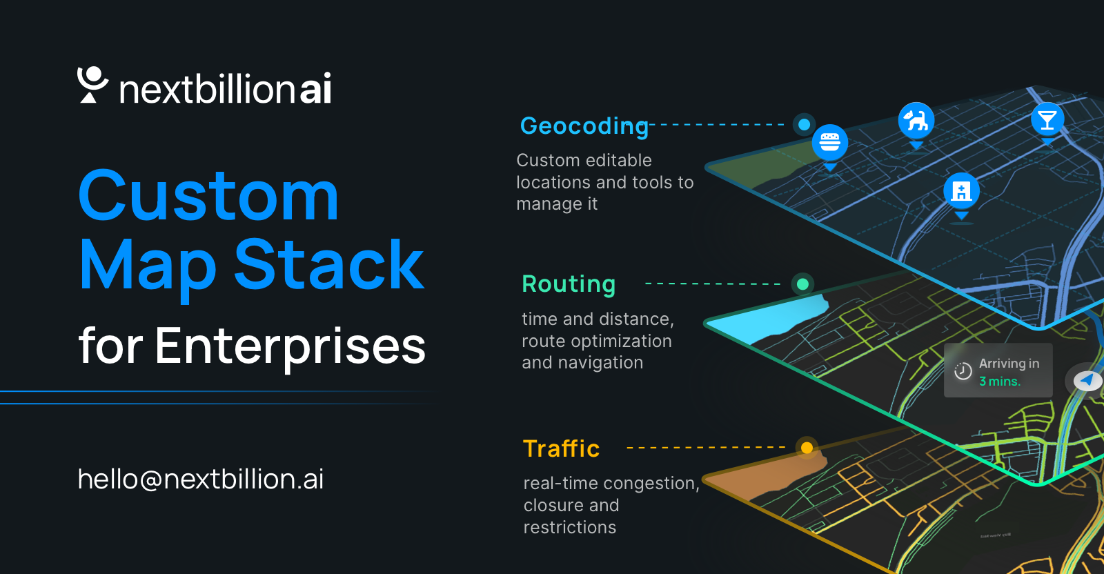
NextBillion.ai’s ML- and AI-driven platform offers solutions in three broad categories:
• Spatial Data Management - Map editing, custom data layers, auto QA, etc.
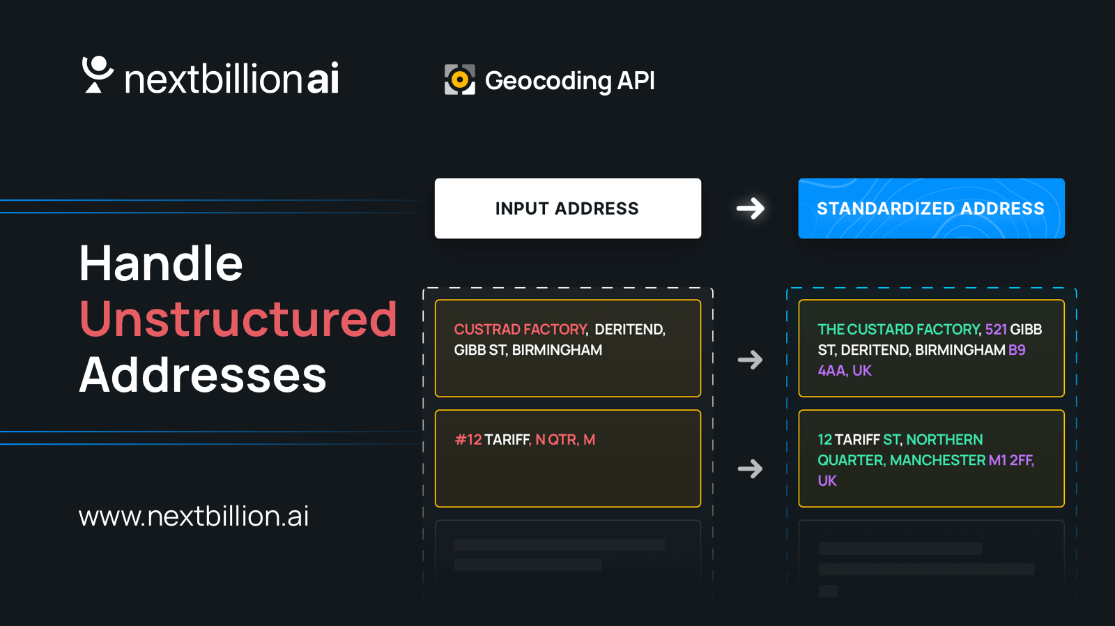
• APIs and SDKs - Navigation, accurate ETAs, unstructured addresses, etc.
• Geospatial Applications - Delivery optimisation, supply chain visibility, location-powered BI, etc
These solutions address the location intelligence needs of a spectrum of industries, from ride-hailing and food delivery to long-haul trucking and emergency services.

|

|

|
| From left to right: NextBillion.ai’s founders Ajay Bulusu, Gaurav Bubna and Shaolin Zheng. | ||
What are some challenges enterprises face in using mapping solutions?
Enterprises face a number of challenges with mapping solutions that hamper their ability to operate at optimal performance levels, including:
Relevance - Unlike NextBillion.ai, most mapping solutions on the market aren’t deeply customisable to the specificities of various use cases. This places limitations on the applications for the technology and the intelligence that can be drawn from it. For instance, a food delivery company may be operating both 2- and 4-wheelers, but unless the routes are optimised for each vehicle type, revenue is being lost through inefficiency.
Hyper-local nuance - It’s hard to capture the intricacies of regional map data at a large scale. There are a number of factors to take into account, from road closures and vehicle- or time-based road restrictions to apartment complex layouts and warehouse entry/exit locations. Such information would be crucial to enterprises. We’re able to effectively capture hyper-local nuances because of our capacity to maintain and integrate fresh data from disparate sources.
Dependence - Other map solution providers don’t allow their customers the control to modify and update map layers independently. This means that even if the customer is aware of a road closure or diversion, they cannot update this information to the platform themselves. Instead, they must contact the solution provider and wait for the update to be implemented at the backend. Clearly, this sort of dependence on the provider is far from ideal for the customer.
Cost - Most maps are designed for individual consumers and not large enterprises. Those that are targetted towards enterprises tend to be prohibitively expensive because of the proprietary ecosystem they operate in, as well as high API costs. NextBillion.ai’s first-of-its-kind decentralised approach to the location intelligence ecosystem enables us to offer targetted, effective solutions at a fraction of traditional enterprise mapping costs.
|
|
| NextBillion.ai is a unified spatial data platform. | |