

Look for a
lock () or https:// as an added precaution. Share sensitive
information only on official, secure websites.
SLA deepens industry collaborations to drive adoption and innovation of geospatial technology through MOU with REDAS
Training programmes on geospatial technology and its applications to be rolled out to the real estate sector.
The Singapore Land Authority (SLA) signed a Memorandum of Understanding (MOU) today with the Real Estate Developers’ Association of Singapore (REDAS) to drive adoption of geospatial technology and spur geospatial innovation in Singapore. The MOU signing ceremony was held at Geo Connect Asia 2022 on 1 June, at the Sands Expo Convention Centre, Marina Bay Sands and witnessed by Minister Edwin Tong SC, Minister for Culture, Community and Youth and Second Minister for Law.
Deepening industry collaborations to drive geospatial innovation
2 As the national geospatial agency, SLA has been collaborating with companies and organisations from across the public and private sectors to create awareness, facilitate the integration of geospatial technologies into their existing operations and support the development of solutions for businesses and communities. The MOU with REDAS follows a series of other MOUs concluded within the past year with Ninja Van, Kabam[1] and the top 5 largest property agencies in Singapore.[2] These collaborations are part of SLA’s larger plan to deepen industry collaborations, and continuously improve SLA’s geospatial products including the national map of Singapore, OneMap and its 3D version to benefit more users.
Incorporating geospatial technology in real estate development
3 Under the MOU, SLA and REDAS will jointly promote awareness of geospatial technologies and organise joint events as well as capability development programs that can address the challenges faced by the real estate and related industries. The initiative will be first rolled out at the Geo Connect Asia 2022, with a seminar organised for industry practitioners titled “Engaging geo-based solutions to enhance building design, operations & maintenance”. Attendees will hear from experts including Mr Jugal Makwana, Global Director, BIM/Digital Engineering, Royal Haskoning DHV, The Netherlands, on geo-based solutions that could enhance efficiency in each stage of real-estate development. SLA would also explore working with developers to place 3D models of their newly launched projects on OneMap to showcase the views at different building vantage points to consumers.
4 President of REDAS, Mr Chia Ngiang Hong said, “We are truly excited to collaborate with SLA. Having SLA share its expertise on geospatial data, services and technology will certainly help advance our members’ and the industry’s current push towards the digitalisation of real estate development. We also look forward to working with SLA to tap on its extensive networks to upskill our members’ and the industry’s geospatial knowledge and competencies to help improve productivity, resilience and sustainability for real estate and related businesses.”
5 SLA Chief Executive Colin Low commented, “Geospatial technology supports many cutting-edge technologies across a wide spectrum of industries. We’ve seen it applied as a catalyst to spark improvement to business operations and their service delivery in many sectors, from optimising routes for delivery of food and parcels, to enhancing the provision of emergency services and even addressing global issues such as climate change. Similarly, through this MOU, we look forward to working with REDAS to pool together our collective expertise and unlock the potential of geospatial technology in the real estate sector.”
6 The MOU marks the first of industry specific engagements that are aimed at showcasing and discussing how geospatial data and technology can address the challenges in the complex and resource intensive real estate development industry across the full cycle of pre-development, development, and post development stages.
7 SLA Director of Geospatial & Data Division, Mr Ng Siau Yong added, “We are excited about the prospects that geospatial technology can enhance and add value to the real estate sector at different development stages. For example, 3D city models can support the design and build of properties at the pre-development stage, as it can aid the review of the placement and extent of solar panels that may be required in a development, or at the marketing stage for prospective buyers in the visualisation of the development in the context of its surroundings.”
8 Following the initial launch at Geo Connect Asia, SLA and REDAS will continue to jointly organise more events to drive awareness and adoption of geospatial technologies related to the real estate sector at events such as the Integrated Digital Delivery Symposium and Singapore Geospatial Festival. The two parties will also jointly identify and develop potential geospatial projects by way of workshops, hackathons and proofs-of-concept to develop innovative solutions to benefit the real estate sector.
=== End ===
Issued by:
Singapore Land Authority
Real Estate Developers’ Association of Singapore
1 June 2022
ANNEX A
Shadow castings – Visualisation of shadow castings on a selected building at specified time of the day.
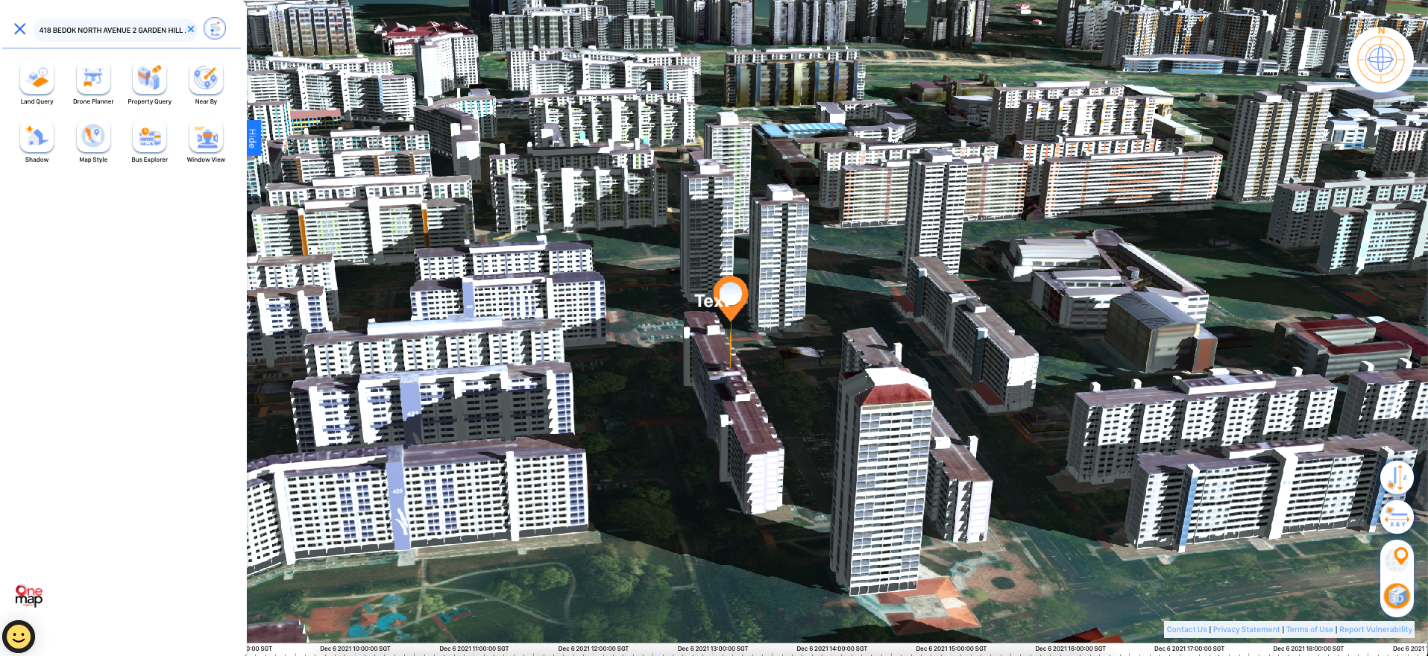
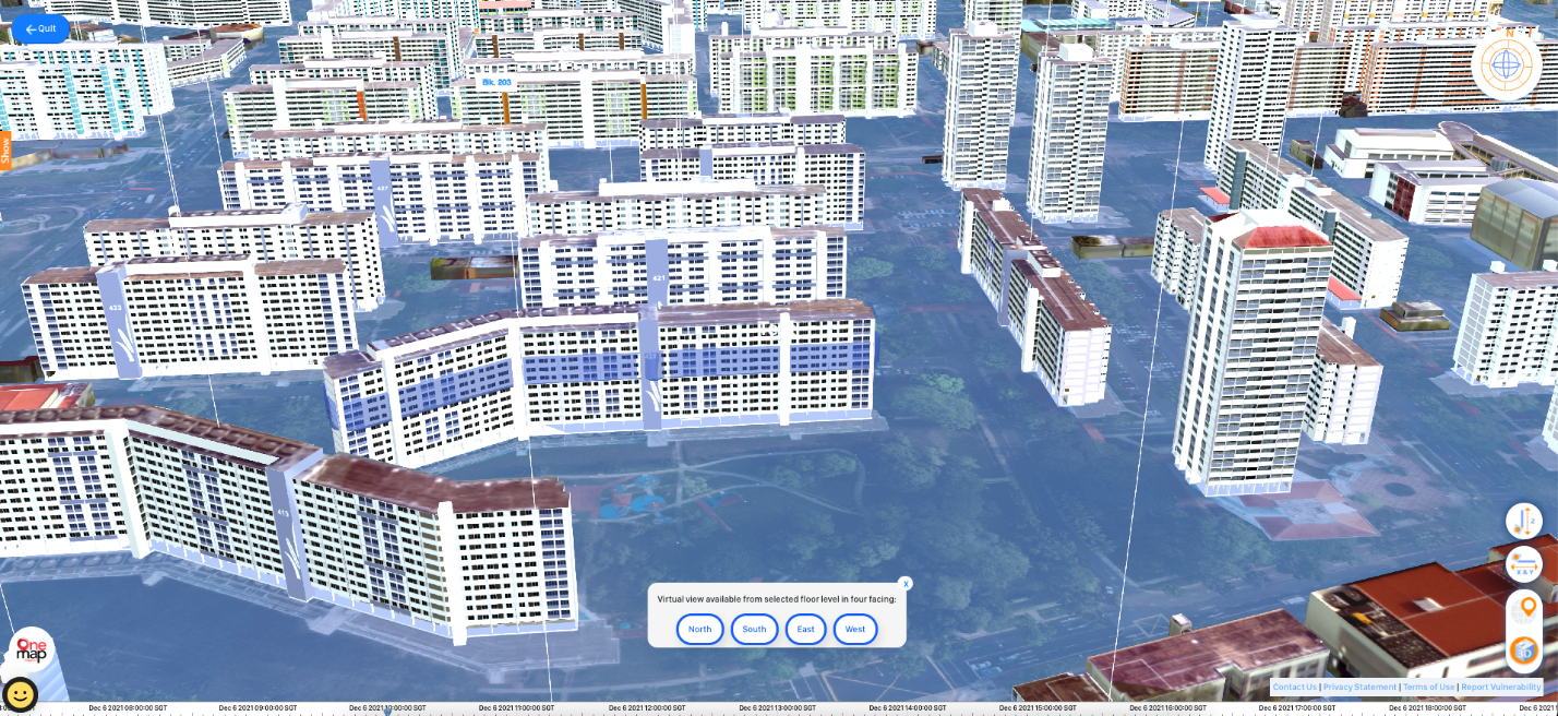
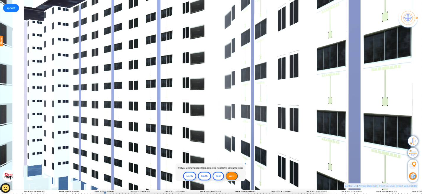
NSEW view from a building – Visualisation of the North, South, East and West view from selected floor of a building.
Drone planner - Visualisation of drone flight path planning and no-fly zone.

[1] SLA launches OneMap3D, and signs MOUs with Ninja Van, Kabam and PropNex to further the use of OneMap