

Look for a
lock () or https:// as an added precaution. Share sensitive
information only on official, secure websites.
10-year Singapore Geospatial Master Plan outlines key land and maritime initiatives for geospatial enabled outcomes to improve lives and enable solutions to complex urban challenges - Annex D-E
ANNEX D
Details of OneMap GPT Challenge Winning Prototypes
(i) Prototype 1 by Winner: Huawei International Pte Ltd
Inter-generational Itinerary Planner/Property Finder
Huawei’s prototype is among the first in the world that integrates geospatial and generative AI technologies with public (OneMap) and private sector data to develop an interactive inter-generational itinerary planner for residents to plan their daily activities or obtain information that can guide lifestyle decisions including consumer purchases.
The prototype developed by Applied Intelligence Centre of Excellence of Huawei International on Huawei Cloud integrates different types of data, such as property information (e.g. EdgeProp, ERA, Propnex), government information (e.g. OneMap datasets, Housing Development Board (HDB) housing policies, National Environmental Agency (NEA) weather information), mobility (e.g. SBS Transit, BlueSG, GetGo, AnyWheel), retail (e.g. Sheng Shiong, UOB TMRW) and lifestyle (e.g. Sentosa Development Corporation, National Library Board (NLB)) datasets.
The prototype can be extended to support other types of user queries, such as planning a day itinerary for property viewings based on specific user preferences, and recommending suitable properties for couples to reside near their parents.
Photograph of prototype 1
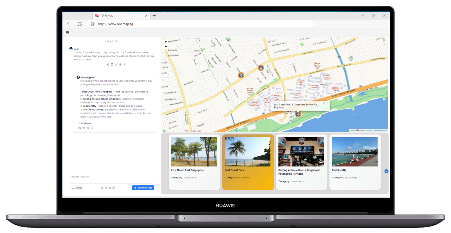
Photo credit: Huawei International Pte Ltd
About Huawei
Founded in 1987, Huawei is a leading global provider of information and communications technology (ICT) infrastructure and smart devices. We have 207,000 employees and we operate in more than 170 countries and regions, serving more than three billion people around the world.
Our vision and mission is to bring digital to every person, home and organization for a fully connected, intelligent world. To this end, we will work towards ubiquitous connectivity and inclusive network access, laying the foundation for an intelligent world; provide diversified computing power where you need it, when you need it, to bring cloud and intelligence to all four corners of the earth; build digital platforms to help all industries and organizations become more agile, efficient, and dynamic; and redefine user experience with AI, making it smarter and more personalized for people in all aspects of their life, whether they're at home, on the go, in the office, having fun, or working out. For more information, please visit Huawei online at www.huawei.com or follow us on:
http://www.linkedin.com/company/Huawei
http://www.facebook.com/Huawei
(ii) Prototype 2 by Winner: Buzz ARVR Pte Ltd
Tourist Buddy
The best way to travel and experience a new country is with a friend. In this case, a digital one. Introducing BuzzAR’s newest development - digital humans. BAE (Buzz's Amazing Entity) is an AI-powered digital human with emotions and expressions, interacting with customers and clients naturally to provide assistance, recommendations, and just good conversation.
BAE aims to create a seamless and interactive end-to-end travel experience for tourists, providing navigational assistance and travel guides to local attractions, restaurants, hotels and events. Imagine a companion, always within reach of your fingertips, providing you contextualised and personalised recommendations and suggestions, while paying attention to your needs and preferences, that is also able to carry a casual conversation about the things you see and the things happening around you.
BAE makes use of OneMap APIs for navigation, routing and display of map-based information. During the development, it also made use of some of OneMap’s open datasets, as well as recommendations from Singapore Tourism Board’s (STB) Tourism Information & Services Hub (TIH) platform. However a large bulk of recommendations from BAE come organically from OpenAI GPT4’s wide knowledgebase. BAE is able to support tourism-related queries, including recommending and planning a customised tourist itinerary based on individual user profiles and preferences.
BuzzAR believes that the next wave of immersive digital experiences in tourism, hospitality and real estate start with these digital humans.
Photographs of prototype 2
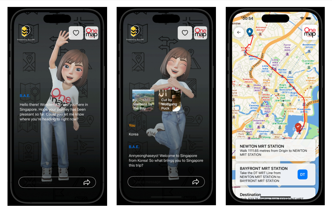
Photo credit: Buzz ARVR Pte Ltd
About Buzz ARVR
BuzzAR – digitizing people, places and payments, and transforming customer interactions. BuzzAR is an AR, VR and AI solutions company developing products that enhance customer experiences for tourism and retail in Singapore and Saudi Arabia. Founded in 2018 by co-founders Bell Beh and Ken Lim, they have since worked with over more than 10 B2B/B2G clients and partners with over 100 companies in their ecosystems. Key products include their AR Wayfinder platform, an interactive kiosk that interacted with customers and digitised faces, and their work on LLM-based AI chatbots and self-hosted LLM solutions.
BuzzAR was part of the Singapore Tourism Accelerator in 2020, and the Saudi Tourism Accelerator in 2022 (hosted by Singapore Tourism Board and Saudi Tourism Authority respectively), as well as the recent Google AI Trailblazers programme.
ANNEX E
Other event highlights
Closing Plenary – Thursday 7 March 3.40pm to 5pm
Mainstreaming Geospatial: Harnessing Geospatial Innovation for Healthcare, Community and Sustainable Development
Jointly hosted by Mr Colin Low, Chief Executive of SLA and Mr David Foo, Chief Executive of MPA, this panel discussion explores the strategies, challenges, and opportunities for making geospatial data and technology more mainstream in sectors such as healthcare, social and sustainability, to enhance the quality of life for citizens and promoting sustainable development.
The discussion will delve into the following key areas:
- Healthcare: Investigating the potential applications of geospatial in managing public health and healthcare delivery. How can geospatial contribute to better understanding of healthcare needs, optimise resource allocation, and improve health outcomes?
- Social/Community Development: Examining the role of geospatial in community development, engagement and the provision of social services. How can geospatial be leveraged to improve access to essential services, enhance social cohesion and promote a more inclusive community?
- Sustainability: Exploring the intersection of geospatial with sustainability initiatives, including environmental conservation, biodiversity protection and enhancing the resilience of our land and marine spaces. How can geospatial better support sustainable development and climate resilience efforts?
Distinguished Panellists:
- Co-host: Mr Colin Low, Chief Executive, Singapore Land Authority
- Co-host: Mr David Foo, Assistant Chief Executive, Maritime and Port Authority of Singapore
- A/Prof Gan Wee Hoe, Chief Executive Officer, SingHealth Community Hospitals
- Mr Jack Lim, Managing Director, Community Chest
- Dr Cheong Wei Yang, Vice Provost (Strategic Research Partnerships), Provost Office, Singapore Management University
- Dr. Jani Thuaibah Isa Tanzil, Senior Research Fellow, Tropical Marine Science Institute, National University of Singapore
Launch of Heavy Vehicle Routing API
Following an MoU signed with the Container Depot and Logistics Association (Singapore), or CDAS, last year, SLA has completed the development of the routing algorithm on OneMap for the western part of Singapore (Pasir Panjang – Tuas) with CDAS’ heavy vehicle traffic data, to enable the CDAS' member companies to route their heavy vehicles efficiently and safely.
To-date, CDAS has developed a prototype on their system allowing drivers to opt for safer routes that accommodate their vehicle’s height and width constraints. With more comprehensive data, the routing algorithm is expected to improve driver safety, reduce fuel and time wastage, increase transportation efficiency and optimise operations.
ASEAN Geospatial Challenge 2024
At the opening of the Geo Connect Asia 2024, Mr Colin Low, Chief Executive of SLA, presented the “Distinction Award” to the winning teams of the ASEAN Geospatial Challenge 2024, which was organised by SLA.
The annual ASEAN Geospatial Challenge brings youth in the ASEAN region together to use geospatial technology and information to support nations in achieving their Sustainable Development Goals (SDGs). Targeted at students from Institutes of Higher Learning (IHLs) in the ASEAN region, the challenge aims to cultivate good relationships and collaborations among the youth in ASEAN, elevate geospatial competencies and facilitate knowledge sharing to raise the overall interest in the geospatial field.
A total of 49 teams from IHLs across four ASEAN countries participated in the competition this year. There were 8 teams from Singapore, 37 teams from Indonesia, 3 teams from The Philippines, and 1 team from Thailand.
The two winning teams of the “Distinction Award” are from the University at Buffalo – Singapore Institute of Management, and Bandung Institute of Technology, Indonesia. The synopses of the projects from the teams are appended.
University at Buffalo – Singapore Institute of Management
The team’s project seeks to revolutionise food waste management in Singapore by utilising geospatial data, combining statistical and advanced geospatial techniques to map and predict food wastage patterns.
Bandung Institute of Technology, Indonesia
The team’s project aims to create a platform that integrates geospatial data to address the critical issue of Asian elephant habitat loss due to deforestation for oil palm plantations in Indonesia.
For more information about the challenge, please visit: ASEAN Geospatial Challenge 2024 (sla.gov.sg)