

Look for a
lock () or https:// as an added precaution. Share sensitive
information only on official, secure websites.
SLA embarks on new collaborations to solve urban challenges with geospatial data and technology
- New Memorandum of Understanding signed with Container Depot and Logistics Association (Singapore) to improve heavy vehicle routing.
- New partnership with SG Enable to pilot test mapping of barrier-free access routes.
- First collaboration signed with Kingdom of Saudi Arabia’s General Authority for Survey and Geospatial Information to exchange knowledge and experiences on geospatial technology adoption to benefit citizens
The Singapore Land Authority (SLA) is embarking on various new collaborations to solve urban challenges by tapping on the possibilities offered by geospatial technology to facilitate data-driven decision making and solutions. Geospatial technology refers to location-based technology which is a key enabler in supporting Singapore’s Smart Nation and sustainability initiatives and is commonly used in areas such as mapping and road navigation.
2 The new collaborations were announced by Dr Amy Khor, Senior Minister of State, Ministry of Sustainability and the Environment, and Ministry of Transport, at the opening of the Geo Connect Asia 2023 on 15 March 2023. At the event, Dr Khor also witnessed the signing ceremonies for two of SLA’s collaborations - with the Container Depot and Logistics Association (Singapore), and the General Authority for Survey and Geospatial Information of the Kingdom of Saudi Arabia. Geo Connect Asia 2023 is an annual international geospatial industry event. Supported by the Singapore Land Authority as the National Geospatial Agency, the event is held from 15 to 16 March 2023 at the Sands Expo & Convention Centre, Marina Bay Sands. Please refer to Annex A for the welcome remarks by Mr Yeoh Oon Jin, Chairman of SLA.
Memorandum of Understanding with Container Depot and Logistics Association (Singapore)
3 In its latest collaboration with the industry, SLA will collaborate with the Container Depot and Logistics Association (Singapore) or CDAS, to improve the routing of heavy vehicles. A Memorandum of Understanding (MOU) was signed by Mr Sin Lye Chong, Assistant Chief Executive (Geospatial & Engagement) and Chief Sustainability Officer of SLA, and Mr Ricky Loo, Deputy President of CDAS. Under the two-year collaboration, CDAS and SLA will utilise geospatial data such as road conditions and restrictions to enable the CDAS's member companies to route their heavy vehicles efficiently and safely.
4 With more comprehensive data, companies that deploy such vehicles and their drivers will be able to plan their journeys better and save time. This will translate into cost savings for the companies as they use less fuel, and also lower their carbon emissions.
Collaboration to Improve Accessibility
5 SLA’s geospatial collaborations go beyond working with the industry. SLA has also been working with SG Enable and Gardens by the Bay to map barrier-free routes to enable wheelchair users to move about easily. This collaboration is part of SLA’s support for the Enabling Masterplan 2030 which sets out the vision for Singapore as an inclusive society by 2030.
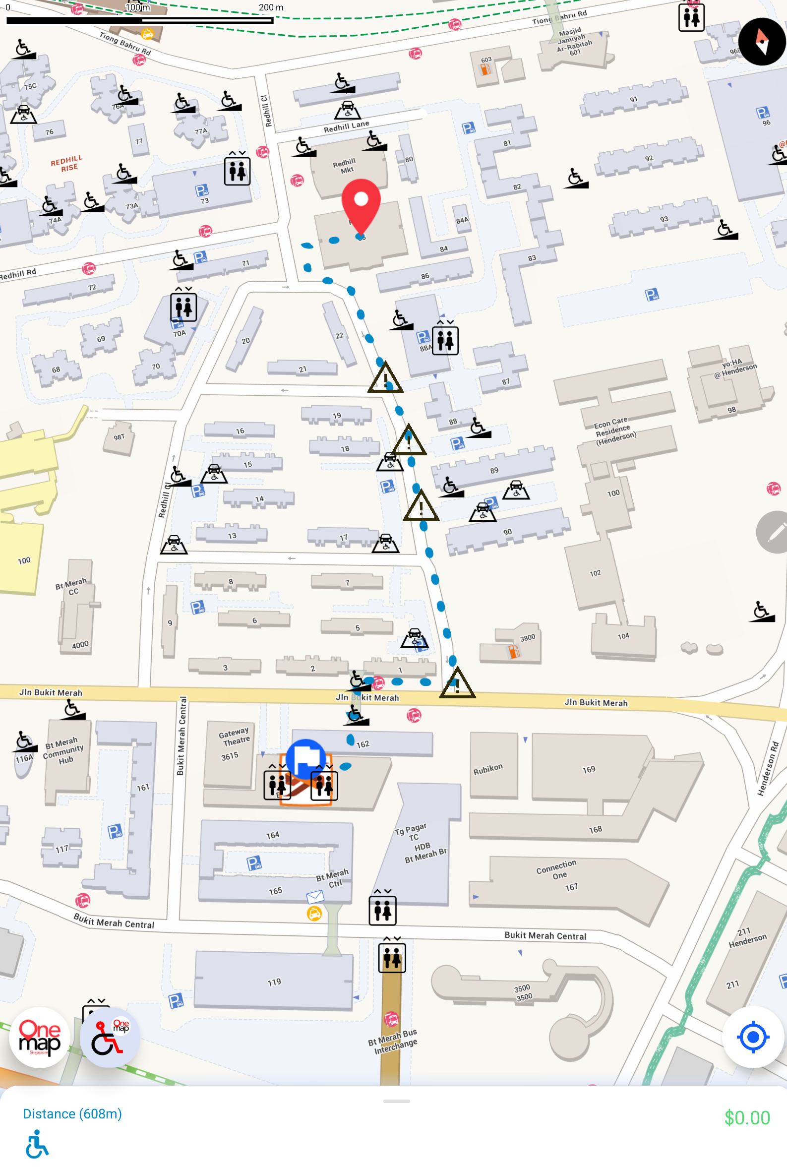
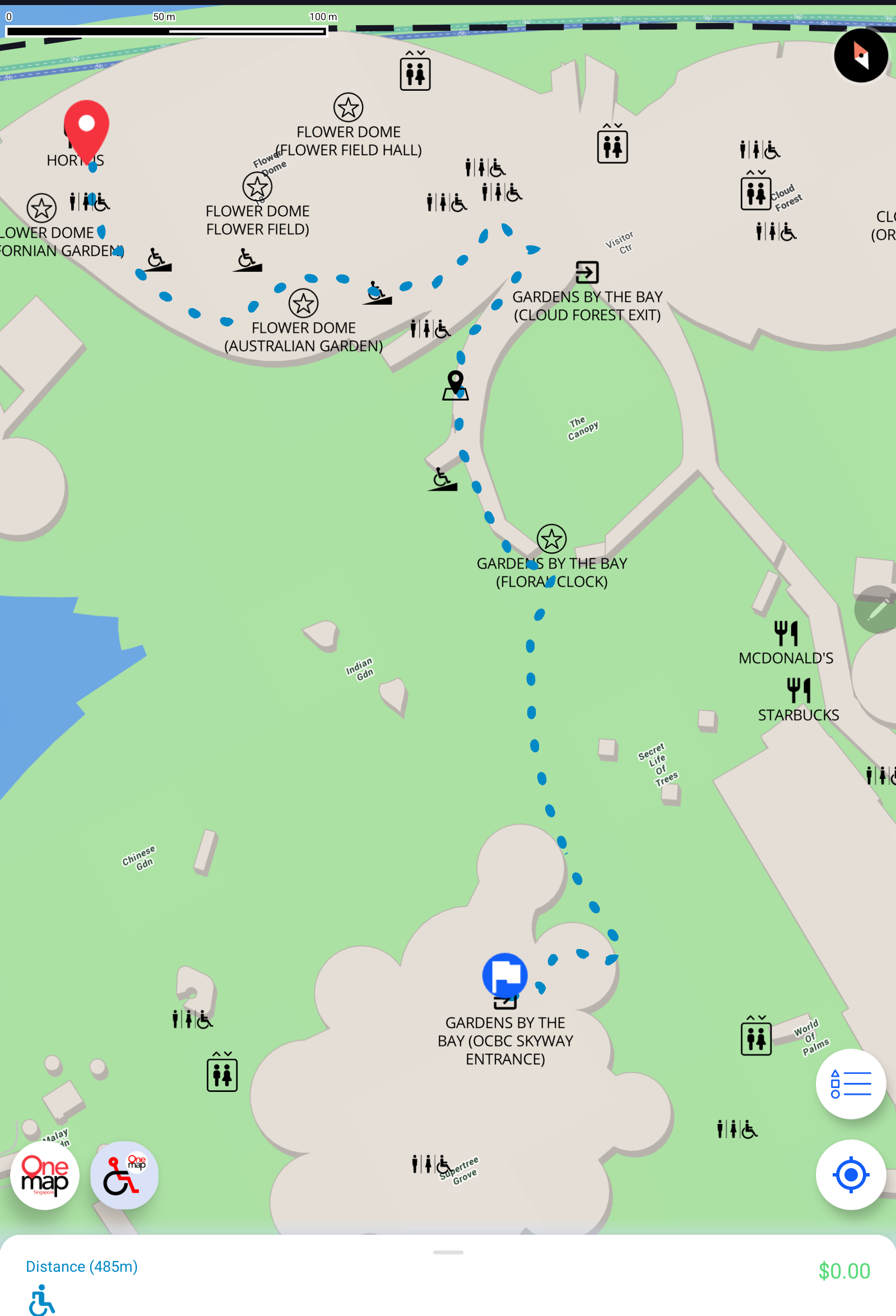
6 In this initiative, data relating to routes that are barrier-free such as those with wheelchair-accessible covered linkways, ramps, footpaths, pedestrian crossings, overhead bridges with lifts are collected and mapped in Bukit Merah and Gardens by the Bay.
7 SLA has developed a pilot testing app with the barrier-free access routes for these two areas to gather feedback and suggestions for improvements from wheelchair users. Improvements in terms of data accuracy and user-friendliness will be incorporated in additional testing areas in the next six months. Eventually, the barrier-free access routing function will be added to OneMap as an additional mode of wayfinding, to supplement the existing public transport, cycling and driving modes. Please refer to Annex B for screenshots of the pilot testing app.
Collaboration with General Authority for Survey and Geospatial Information of the Kingdom of Saudi Arabia
8 As part of SLA’s efforts to foster international knowledge exchange and contribute our experiences in the use of geospatial data and technology, SLA has also embarked on its first bilateral collaboration with the General Authority for Survey and Geospatial Information (GEOSA), Kingdom of Saudi Arabia. The collaboration stems from both countries’ rapid urbanisation, which has seen an increasing need to harness geospatial data and technology in decision making, as there are similar challenges faced by global cities which could benefit from shared solutions. The collaboration with GEOSA, which will be over a three-year period, will entail exchange of knowledge and experiences on:
- the development and management of national geospatial databases;
- the use of technologies such as Artificial Intelligence, Machine Learning in the development of Digital Twins;
- digital transformation in the geospatial industry; and
- development of geospatial products and services that will benefit citizens.
9 Mr Sin Lye Chong, Assistant Chief Executive (Geospatial & Engagement) and Chief Sustainability Officer of SLA, and Mr Asim Ibrahim AlGhamdi, Assistant President of GEOSA for National Geospatial Center, signed an Intent of Collaboration at the side-lines of the Geo Connect Asia 2023.
10 Please refer to Annex C for the quotes from the partners and the photos of the signing ceremonies.
Charting out the focus on education
11 At the opening of the Geo Connect Asia 2023, Dr Amy Khor also presented the “Distinction Award” to two winning teams of the ASEAN Geospatial Challenge 2023, which was organised by SLA. The annual challenge brings youths from the ASEAN region together to solve real life problems using geospatial technology and information. Please refer to Annex D for more information about the challenge and the winning projects.
12 SLA has been working with partners to inculcate geospatial interest and awareness among students by exciting them about the potential of geospatial technologies to solve everyday challenges in our community. Other examples of such initiatives include the annual Global Navigation Satellite Systems (GNSS) Innovation Challenge co-organised with the Space Faculty, the annual Regional Geospatial Youth Forum, and the Young Geospatial Scientist workshop in partnership with Singapore Science Centre. New educational initiatives for students will be announced later this year. Through these initiatives, SLA aims to mainstream the use of geospatial data and capabilities.
=== End ===
Issued by:
Singapore Land Authority
15 March 2023
ANNEX A
Welcome Remarks by Mr Yeoh Oon Jin, Chairman, Singapore Land Authority at the Opening of Geo Connect Asia at Sands Expo & Convention Centre, Marina Bay Sands, Singapore on 15 March 2023 (Wednesday)
Introduction
1. A very good morning to:
a) Our Guest-of-Honour, Dr Amy Khor, Senior Minister of State for Sustainability and the Environment and Senior Minister of State for Transport;
b) Dr Nadine Alameh, Chief Executive Officer, Open Geospatial Consortium;
c) Mr Asim Ibrahim Al-Ghamdi, Assistant President, General Authority for Survey and Geospatial Information of the Kingdom of Saudi Arabia;
d) Ms Ku Geok Boon, Chief Executive Officer, SG Enable;
e) Mr Ricky Loo, Deputy President, Container Depot and Logistics Association of Singapore, and
f) Distinguished guests, ladies and gentlemen.
2. Welcome to the opening of the Geo Connect Asia 2023. Our guests in the room today come from many overseas countries and various industries, and we are very glad to be able to host you in Singapore this week.
3. As the national geospatial agency, the Singapore Land Authority actively supports the adoption of geospatial services and technologies. This is a collaborative effort together with our esteemed partners, including those from various industries that are here with us today.
Geospatial is Growing in Significance
4. In Singapore, geospatial is growing in significance and importance. It is being applied to support our social, economic and environmental development. For example,
- Geospatial supports business transformation. We had recently signed MOUs with the Singapore Business Federation, Real Estate Developers’ Association of Singapore, Ninja Van, Kabam and the top 5 largest property agencies in Singapore to drive geospatial adoption and innovation.
- Geospatial is an enabler for sustainable development. SLA has partnered research institutions to harness geospatial data for climate change studies. Last year, SLA signed MOUs with the Earth Observatory of Singapore, and the National University of Singapore’s Centre for Nature-based Climate Solutions, to leverage on SLA’s geospatial capabilities for coastal protection studies and carbon estimation research.
The Next Bound
5. We are just at the beginning of unleashing the full potential of geospatial. Why stop at upstream planning as traditionally done? How can we use hyperlocal maps to help persons with disabilities move around Singapore barrier-free? How can we map peoples’ needs and provide targeted social assistance? Going forward, we will continue to experiment on using geospatial datasets in novel ways. We will deepen our own geospatial capabilities, broaden our partnerships, and continue to mainstream geospatial in businesses as well as in sustainable development.
6. At the same time, we will leverage on Singapore’s strength as a global hub to generate more opportunities for the geospatial sector. Businesses can take advantage of our well-established infrastructure, conducive business environment and geospatial expertise, and use Singapore as a living lab and launch-pad to the regional markets.
7. We will continue to broaden our outreach efforts, establish more international collaborations and strengthen our networks across the globe. By bringing together geospatial experts and businesses from around the world to Singapore, Geo Connect Asia is an excellent platform for us to make important connections and create new opportunities.
Sharing Expertise beyond Singapore
8. Just yesterday, we welcomed thought leaders from around the world to the International Seminar on Geo-Enabled Effective Land Administration organised by SLA. Singapore also contributes to international geospatial development by co-chairing the UN’s Expert Group on Land Administration and Management, led by SLA’s Dr Victor Khoo. We will continue to contribute our expertise to support the global geospatial development agenda.
9. On this note, I am happy to share that SLA will be entering into a collaboration with Saudi Arabia’s General Authority for Survey and Geospatial Information today, for SLA to contribute its expertise in geospatial development. We are grateful to Saudi Arabia for supporting our shared vision to raise geospatial capabilities globally, and we are excited about further possibilities that will arise from this collaboration.
Closing
10. I am optimistic that by working together and across business sectors and domains, we will continue to make further strides in geospatial development in the coming years.
11. Indeed, I am very pleased to see the strong turn-out at the 3rd Geo Connect Asia, which speaks volumes about the growing interest in the relevance of geospatial applications in our daily lives. I am confident that you will have many opportunities to exchange ideas and forge new partnerships at this conference.
12. I wish everyone a very fruitful conference ahead. Thank you.
ANNEX B
Screenshots of the pilot testing app on barrier-free access routes
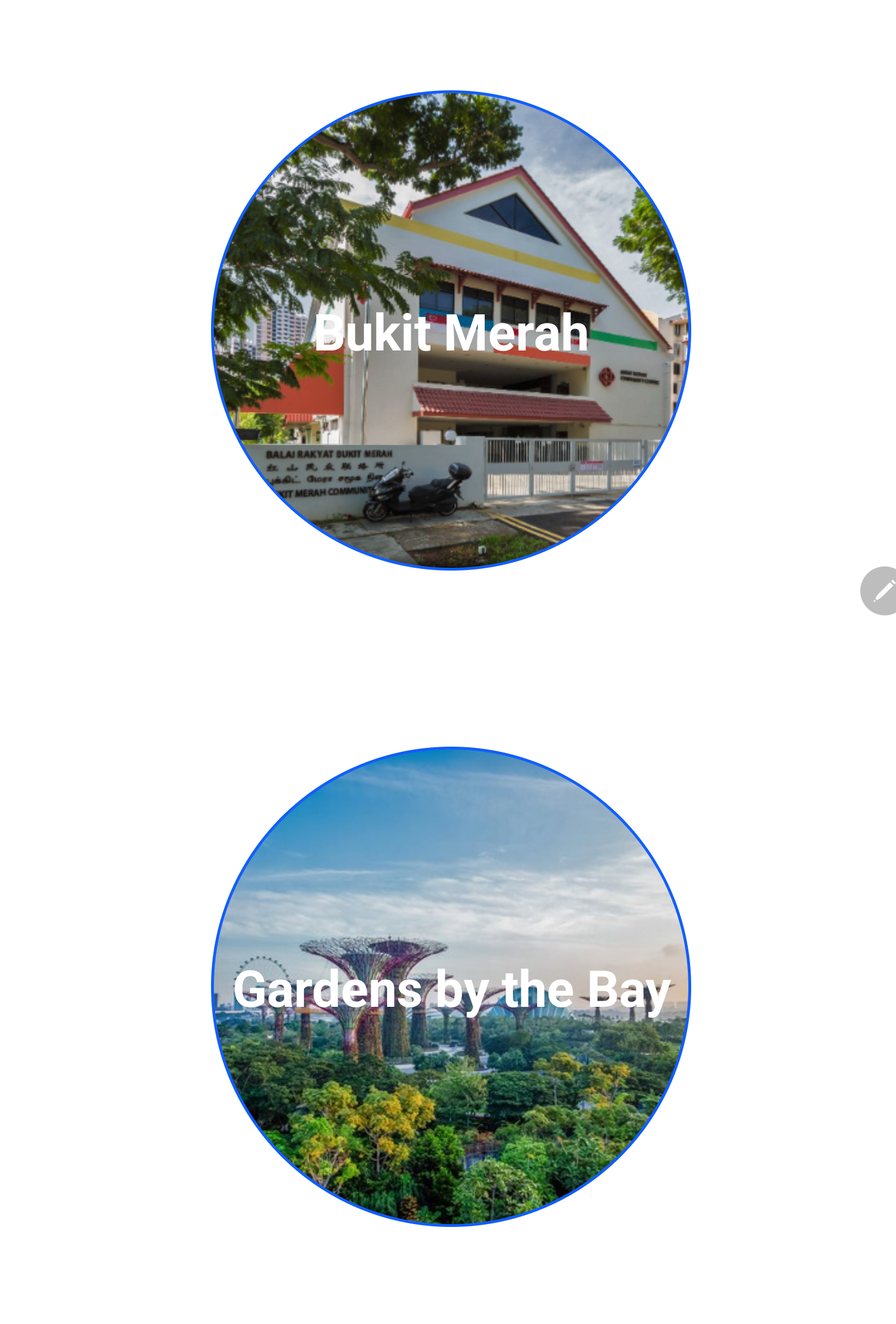
Picture 1
Main page of pilot testing app
Picture 2
Barrier-free access navigation route in Bukit Merah
Picture 3
Barrier-free access navigation route in Gardens by the Bay
ANNEX C
Quotes from SLA and partners
As the National Geospatial Agency, SLA is actively looking into how we can “mainstream” geospatial data and technologies to increase their applications so as to solve the urban challenges that cities face. These collaborations with our partners show that geospatial innovations can solve many different types of challenges and contribute to a more sustainable and inclusive society. We are also very happy to be able to share our geospatial knowledge and experiences with our overseas counterparts. SLA will continue to raise awareness on geospatial developments, be it in sectors such as sustainability, social services or education so that more can benefit from the use of geospatial data and technology.
- Mr Colin Low, Chief Executive, Singapore Land Authority
Together with SLA, CDAS will help promote awareness in geospatial technologies and their potential areas of application to further benefit our members and the industry at large. To show our commitment to this, CDAS has integrated OneMap as the map choice for the Container Tracking System (CTR) to not just benefit the depots and hauliers of the logistics industry, but to also expand on the capabilities of OneMap.
Working hand in hand, I am confident that SLA and CDAS will be able to identify, and develop promising potential geospatial co-innovation projects, and find solutions that will address the challenges faced by the logistics and transportation industry, and bring it to greater heights.
- Mr Ricky Loo, Deputy President, Container Depot and Logistics Association (Singapore)
An accessible physical environment is key in enabling persons with disabilities to live independently. SG Enable is excited to partner SLA on this pilot project to identify barrier-free routes and enable navigation within the selected areas. We hope to see more social innovations like this that contribute towards a more inclusive commuting experience for persons with disabilities.
- Ms Ku Geok Boon, Chief Executive Officer, SG Enable
As a People’s Garden, Gardens by the Bay aims to be a place for one and all in the community to gather, which is why universal accessibility has always been part of our design approach since we opened our doors to the public 10 years ago. We are pleased to be amongst the first to participate in this pilot project collaboration with SLA, which upon completion, will see Gardens by the Bay’s barrier-free access routes included in OneMap as an additional wayfinding option for our visitors.
- Mr Felix Loh, Chief Executive Officer, Gardens by the Bay
I take this opportunity to welcome this cooperation between our friendly nations. It is a great opportunity for our two organisations to share their knowledge and experience and gives us an opportunity to benefit from the Singaporean experience in geospatial information management. Via this collaboration, we look forward to enhancing the operations of National Geospatial Center, that is responsible for sharing of geospatial data, products, solutions, and services in Saudi Arabia. We look forward to jointly work together on establishing strong relationship with geospatial data theme custodians, producers, and users to ensure the availability of timely and useful geospatial information in an easy, safe, secure, and reliable manner. We also look forward to working together to identify opportunities in developing capabilities to enhance the Center.
- Mr Asim AlGhamdi, Assistant President of GEOSA for the National Geospatial Center (NGC)
Photos from signing ceremonies
Memorandum of Understanding by SLA and Container Depot and Logistics Association (Singapore)
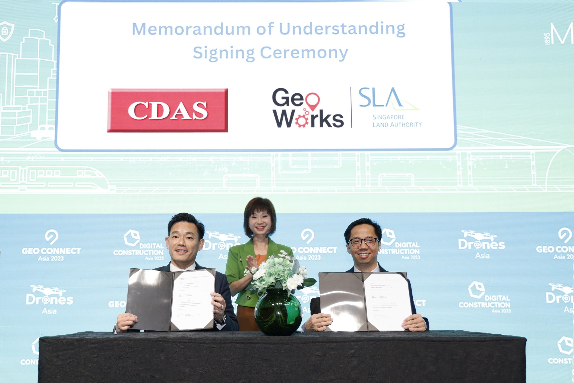
Mr Sin Lye Chong, Assistant Chief Executive (Geospatial & Engagement) and Chief Sustainability Officer of SLA (right), and Mr Ricky Loo, Deputy President (left), Container Depot and Logistics Association (Singapore), signed a Memorandum of Understanding to improve heavy vehicle routing. The signing was witnessed by Dr Amy Khor (centre), Senior Minister of State, Ministry of Sustainability and the Environment, and Ministry of Transport.
Signing of Intent of Collaboration by SLA and General Authority for Survey and Geospatial Information of the Kingdom of Saudi Arabia
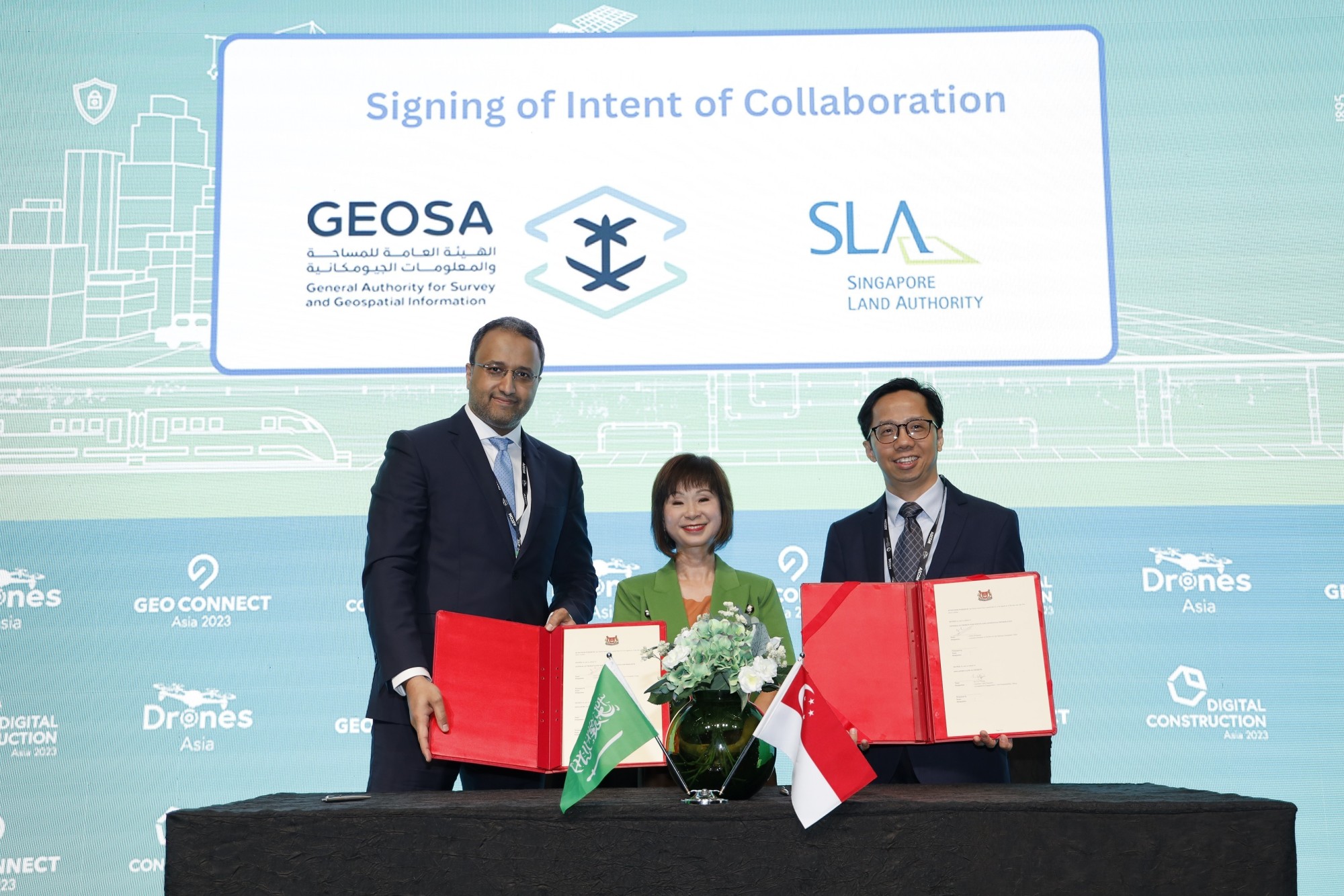
Mr Sin Lye Chong, Assistant Chief Executive (Geospatial & Engagement) and Chief Sustainability Officer of SLA (right), and Mr Asim Ibrahim AlGhamdi, Assistant President of GEOSA for National Geospatial Center (left), signed an Intent of Collaboration on 15 Mar 2023, to exchange knowledge and experiences on geospatial technology adoption. The signing was witnessed by Dr Amy Khor (centre), Senior Minister of State, Ministry of Sustainability and the Environment, and Ministry of Transport.
ANNEX D
ASEAN Geospatial Challenge 2023
The ASEAN Geospatial Challenge 2023: Geospatial Youth Edition brings youth in the ASEAN region together to use geospatial technology and information to support nations in achieving their Sustainable Development Goals (SDGs). Targeted at students from Institutes of Higher Learning (IHLs) in the ASEAN region, the challenge aims to:
(i) Cultivate good relationships and collaborations among the youth in ASEAN;
(ii) Elevate geospatial competencies and facilitate knowledge sharing;
(iii) Raise interest in the geospatial field.
2 Entries are submitted by Geospatial Agencies from Indonesia (Badan Informasi Geospatial), Philippines (National Mapping and Resource Information Authority) and Singapore (Singapore Land Authority).
3 A total of 33 teams from 23 IHLs across three ASEAN countries participated in the competition this year. Singapore fielded ten teams. Indonesia fielded 21 teams. The Philippines sent two teams.
4 The two winning teams of the “Distinction Award” are from the Singapore Management University and Bandung Institute of Technology, Indonesia. The synopses of the projects from the teams are appended.
Singapore Management University
The team’s project aims to address the current challenges of connecting people who need help or resources with those who can provide them. Recognising that there has to be a way to connect these stakeholders based on location, availability and nature of assistance easily and safely, the team has proposed a mobile app to match Non-Profit Organisations with volunteers based on location, availability and nature of assistance. The solution will better connect volunteers with their beneficiaries to build cohesive and sustainable communities.
Bandung Institute of Technology, Indonesia
The team’s project aims to provide information that will help users assess land suitability for crop production and prioritise areas for irrigation. The team has proposed a Geographic Information System (GIS) mobile app that will leverage remote sensing datasets and machine learning to generate models showing land suitability for agriculture, from the least suitable to the most suitable. It will also show the areas that can be prioritised for irrigation network development. The solution will contribute to more effective and efficient agricultural policies, and increase the opportunities for long-term investment.
5 For more information about the challenge, please visit: https://geospatial.sla.gov.sg/initiatives/geochallenges/