

Look for a
lock () or https:// as an added precaution. Share sensitive
information only on official, secure websites.
Singapore Land Authority hosts the first International Seminar on United Nations Global Geospatial Information Management in Southeast Asia
1. Held in Southeast Asia for the first time, the Singapore Land Authority (SLA) is hosting the International Seminar on United Nations Global Geospatial Information Management (UN-GGIM) from 16 to 20 May 2022. Themed “Effective Land Management”, the international seminar aims to set the agenda for the development of global geospatial information and is an important forum for experts to address key global challenges such as climate change and sustainable development using geospatial information.
2. The International Seminar is officially opened by Mr. Calvin Phua, Deputy Secretary, Ministry of Law, Singapore today at Suntec Singapore Convention & Exhibition Centre. Mr. Hugh Lim, Executive Director, Centre for Liveable Cities delivered a keynote speech on Land Administration and Management. Mr. Colin Low, Chief Executive, Singapore Land Authority, Mr. Teo Chee Hai, Senior Advisor, United Nations Secretariat – Global Geospatial Information Management, and Ms. Quah Ley Hoon, Chief Executive, Maritime and Port Authority of Singapore gave opening addresses at the event.
3. More than 120 leading international experts from 22 countries across industry, academia and governmental agencies in the field of global geospatial information management are gathered at the seminar to share and exchange their expertise on strategies to address key global issues such as climate change, efficient urban planning and effective land administration for the wellbeing of society, economy and environment. The plenary sessions will cover topics including the integration of data and information from the terrestrial, maritime and cadastral domains, the availability and accessibility of reliable, timely and quality land information and the rights, restrictions and responsibilities for secure land and property rights. Please refer to the Annex for the full programme of the International Seminar.
4. The International Seminar is also held alongside the Fourth Expert Meeting of the United Nations Working Group on Land Administration and Management. These meetings provide a forum for dialogue and coordination among members of the Expert Group together with invited experts to translate concepts into practical guidance for the implementation of the Framework for Effective Land Administration (FELA) at the country level.
SLA’s 3D National Mapping efforts

Different types of 3D data for the development of digital twin
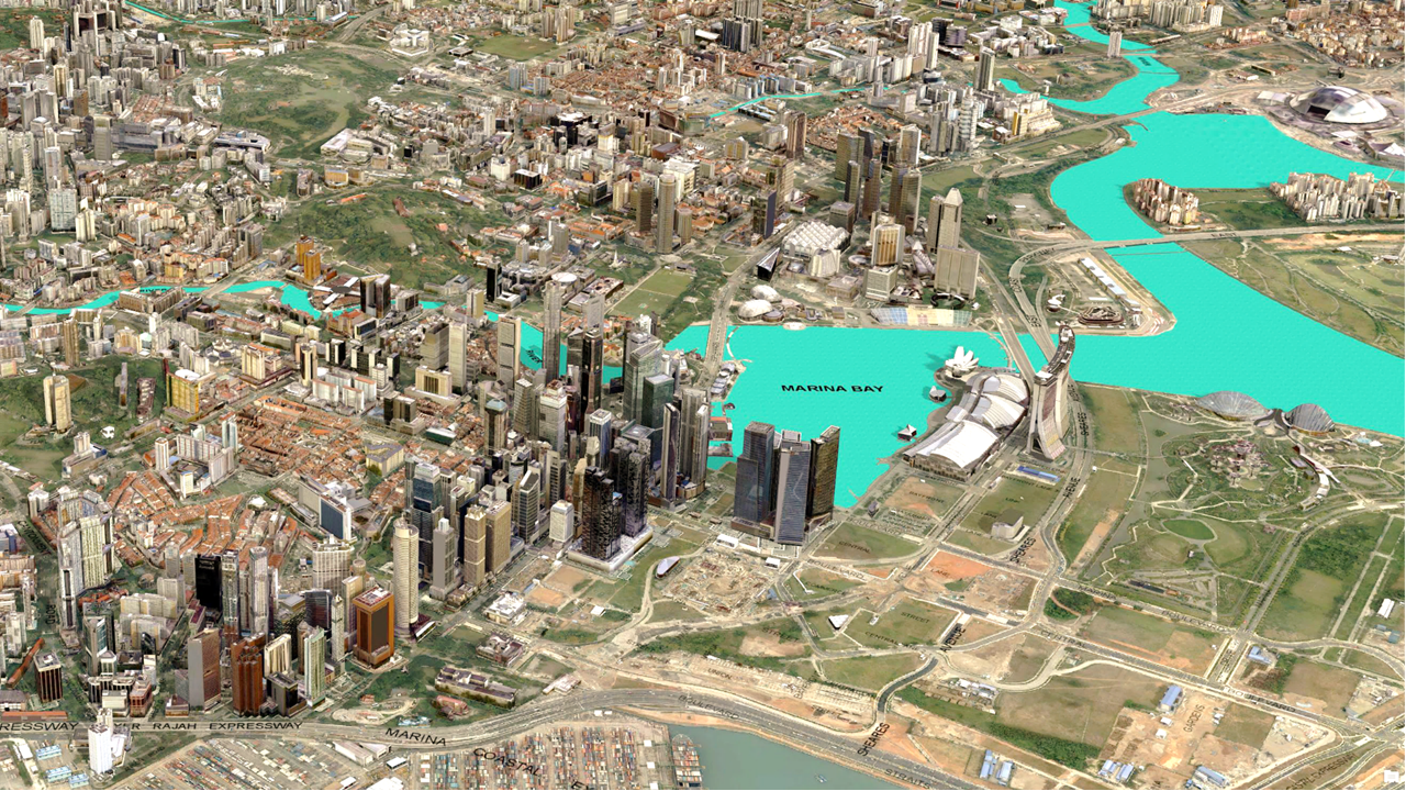
Digital twin of Singapore
6. Chief Executive of SLA, Mr Colin Low, said: “SLA is honoured to host the UN-GGIM event whose global experts developed frameworks such as the Integrated Geospatial Information Framework (IGIF) and Framework for Effective Land Administration (FELA), that embody their wisdom for effective land administration. Location or geospatial knowledge plays an integral role towards the socio-economic development of cities and countries today. To manage land effectively and address increasing climate change challenges, the Singapore Digital Twin (SG Digital Twin), encompassing 3D City models, terrain models, cadastral information, underground assets, coastline, and more, provides the foundation of data that allows us to accurately and efficiently plan and prepare for complex land environmental issues. We are delighted to share SLA’s experience in this area as a showcase of how geospatial data can be used to improve the lives of our citizens.”
7. Director of SLA’s Survey and Geomatics Division, Dr Victor Khoo, adds: “In SLA, we are piloting Building Information Model (BIM) technology for 3D Strata cadastral administration, in high-rise communal living to take a 3D inventory of volumetric spaces at the unit level, for each residential or commercial occupant. The SG Digital Twin enables more effective asset design, project execution and asset operation. By leveraging on 3D datasets, spatial planning can take into account land ownership, transport accessibility, service connectivity, safety concerns, environmental considerations, and skyline aesthetics all at the same time. The expansion of these data sets contribute towards the digital transformation of the AEC industry and the built environment as public agencies can also review the proposed digital designs simultaneously with a single coordinated approval from regulatory agencies.”
8. SLA will also be participating in the World Cities Summit in July this year to present the importance and benefits of geospatial solutioning. SLA will showcase SG Digital Twin to raise awareness of location data's role in managing the city among city leaders.
--- END ---
Issued by
Singapore Land Authority
17 May 2022
Annex – Full Programme
Monday 16 May 2022
| Closed Door meeting | |
Tuesday 17 May 2022 | International Seminar on UN-GGIM: Day 1 (Room: Hall 406) | |
8:15 a.m. – 9:00 a.m. | Arrival and registration of participants (Registration Desk in front of Hall 406) | |
9:00 a.m. – 10:30 a.m. | Official Opening Ceremony Joint official opening ceremony for the International Seminar on United Nations Global Geospatial Information Management with the theme “effective land administration”, the meeting of the Executive Board of the Regional Committee of United Nations Global Geospatial Information Management for Asia and the Pacific, and the fourth meeting of the United Nations Expert Group on Land Administration and Management. The session includes an official opening address by an invited Guest of Honor followed by a number of welcome remarks, a keynote speech and an introduction on UN-GGIM.
Facilitator: Mr. Evert MULDER Singapore Land Authority
Welcome Address
Chief Executive, Singapore Land Authority Singapore
Opening Address
Deputy Secretary, Ministry of Law Singapore
Welcome Remarks
Chief Executive, Maritime and Port Authority Singapore
Co-Chair, United Nations Expert Group on Land Administration and Management The Netherlands
Keynote Speech
Executive Director, Centre for Liveable Cities Singapore
Introduction on UN-GGIM
Senior Advisor, United Nations Secretariat – Global Geospatial Information Management | |
10:30 a.m. – 11:15 a.m. | Break | |
11:15 a.m. – 1:00 p.m. | Plenary Session #1 Effective land administration for the wellbeing of society, economy and environment Effective land administration provides humanity with better access to and security of land and property rights, essential to achieve national development priorities and leaving no one behind - the commitment of the 2030 Agenda for Sustainable Development. This session discusses the significance and relevance of effective land administration leveraging the United Nations Framework for Effective Land Administration (FELA) for the wellbeing of people, planet, peace, partnership and prosperity of countries. (Each presentation will be of 15 - 18 minutes duration allowing time for moderated discussion)
Facilitator: Mr. Kees de ZEEUW United Nations Expert Group on Land Administration and Management
Presentations:
Mr. CHEOH Wee Keat Singapore Land Authority, Singapore
Mr. Kees de ZEEUW Kadaster International, The Netherlands
Mr. CHING Tuan Yee Urban Redevelopment Authority, Singapore
Ms. Meizyanne HICKS Ministry of Lands and Mineral Resources, Fiji
Mr. Winston CHOW Singapore Management University, Singapore
Moderated open discussion | |
1:00 p.m. – 2:30 p.m. | Lunch (Room: Hall 406) | |
2:30 p.m. – 4:00 p.m. | Plenary Session #2 Integration of terrestrial, cadastral and maritime domain Evidence-based policy development and decision making leading to effective governance of a country’s ‘total’ space, inclusive of the natural and built environment, require the integration of data and information from the terrestrial, maritime and cadastral domains. This session considers the importance of integrating data and information from these domains with any other meaningful data for the needed evidence-based policy development and decision making. The presentations not only discuss the value and benefits from the integration but also the issues and challenges of the integration for effective administration and governance of the country’s total ‘space’. (Each presentation will be of 15 minutes duration allowing some time for moderated discussion)
Facilitator: Ms. Pearlyn PANG Maritime and Port Authority of Singapore
Presentations:
Mr. Eric Foo Maritime and Port Authority of Singapore, Singapore
Mr. Ramon HANSSEN Technical University of Delft, The Netherlands
Mr. OOI Seng Keat Tropical Marine Science Institute, Singapore
Mr. Chris BODY International Organization for Standardization Technical Committee 211
Mr. Antonius WIJANARTO Geospatial Information Agency, Indonesia
Moderated open discussion
| |
4:00 p.m. – 4:30 p.m. | Break | |
4:30 p.m. – 6:00 p.m. |
Plenary Session #3 Integration of building information modelling and the cadastre This session considers the importance of integrating the built environment into the cadastre. Geocoding building information modelling unlocks its value and allows the integration of natural and built environment data and information towards resilient and sustainable urban environment. This session also discusses the institutional and technical consideration when integrating BIM and the cadastre for a multiplicity of purposes. (Each presentation will be of 15 minutes duration allowing time for moderated discussion) Facilitator: Mr. Gerry ONG ASEAN Federation of Land Surveying and Geomatics
Presentations:
Mr. Clement TSENG Building and Construction Authority, Singapore
Mr. Rudi STOUFFS National University of Singapore, Singapore
Ms. Magdalena ANDERSSON Lantmateriet, Sweden
Mr. Faheem KHAN Leica Geosystem, Singapore
Moderated open discussion
| |
Wednesday 18 May 2022 | EG-LAM Meeting and Technical Visits | |
9:00 a.m. – 1:00 p.m. | EG – LAM Meeting (Room: Nicoll 3) | |
1:00 p.m. – 2:00 p.m. | Lunch (Room: Nicoll 2) | |
2:00 p.m. – 6:00 p.m. | Technical Visits to Earth Observatory of Singapore and GeoWorks | |
|
| |
Thursday 19 May 2022 | International Seminar on UN-GGIM: Day 2 (Room: Hall 406) | |
8:30am – 9:00am | Arrival of participants | |
9:00 a.m. – 10:45 a.m. | Session #4 Rights, restrictions and responsibilities for secure land and property rights Rights, restrictions and responsibilities for secure land and property rights, including marine spaces, are inter-related and have to be administered responsibly and effectively. This session considers the organization and integration of attributes related to rights, restrictions and responsibilities, including the spatial extent, duration, people involved and purpose in a uniform fashion and stored in authentic registers. (Each presentation will be of 15 – 18 minutes duration allowing time for moderated discussion)
Facilitator: Mr. Rohan BENNETT International Federation of Surveyors
Presentations:
Mr. Rohan BENNETT Commission 7, International Federation of Surveyors
Mr. Neil COHN Chia Network
Mr. Mika-Petteri TORHONEN World Bank
Ms. Glenda HEIKERK Management Institute for Land registration and Information System, Suriname
Moderated open discussion
| |
10:45 a.m. – 11:15 a.m. | Break | |
11:15 a.m. – 1:00 p.m. | Session #5 Availability and accessibility of reliable, timely and quality land information This segment considers the importance of up-to-date information that is consistently available and accessible over space and time for good land administration and management, leading to good land governance and sustainable development. In this session we will hear from industry, academia and governmental agencies how they ensure the availability and accessibility of reliable, timely and quality land information for effective land administration benefitting society, environment and economy. (Each presentation will be of 15 - 18 minutes duration allowing some time for moderated discussion)
Facilitator: Mr. Victor KHOO Singapore Land Authority
Presentations:
Ms. Emelyne V TALABIS Land Management Bureau, Philippines
Mr. Peter CREUZER Landesamt für Geoinformation und Landesvermessung Niedersachsen, Germany
Mr. Andrick LAL Pacific Forum
Mr. Brent JONES
Ms. LOH Sook Yee Maxar Technologies, Singapore
Moderated open discussion
| |
1:00 p.m. – 2:30 p.m. | Lunch (Room: Hall 406) | |
2:30 p.m. – 4:00 p.m. |
Session #6 Key elements for implementing the Framework for Effective Land Administration This session considers the translation of high-level concepts to practical guidance for use by Member States leveraging the Framework for Effective Land Administration and its nine pathways. The pathways are intended to guide the implementation of FELA, support the operationalization of IGIF at the country-level and ultimately achieve national development priorities, secure land and property rights for all, and sustainable development. (Each presentation will be of 15 minutes duration allowing some time for moderated discussion)
Facilitator: Mr. Brent JONES ESRI
Presentations:
Mr. TEO Chee Hai UN-GGIM
Mr. Mohamed RAFEEK Survey Department, Sri Lanka
Ms. Paula DIJKSTRA Kadaster International, The Netherlands
Ms. Eva-Maria UNGER Kadaster International, The Netherlands
Moderated open discussion
| |
4:00 p.m. – 4:30 p.m. | Break | |
4:30 p.m. – 5:15 p.m. |
Closing session This session is a panel that gathers all the facilitators to provide a succinct summary of the sessions they have moderated before the presentation of an outcome statement of the International Seminar.
Facilitator: Mr. Kees de ZEEUW Co-Chair, United Nations Expert Group on Land Administration and Management
Closing summaries A moderated panel discussion involving all session facilitators to summarize and present recommendations from their sessions, way forward including key considerations for the implementation of the Framework for Effective Land Administration towards effective land administration for the benefit of all.
Panelists:
Moderated open discussion
| |
5:15 p.m. – 6:00 p.m. |
Closing ceremony The outcome statement of the International Seminar will be presented before the international seminar brought to a close with an official closing statement.
Facilitator:
Outcome statement
Closing remarks
Official closing statement
| |
Friday 20 May 2022 | Closed door meeting | |
| END OF THE EVENT | |