

Look for a
lock () or https:// as an added precaution. Share sensitive
information only on official, secure websites.
Singapore Land Authority and National University of Singapore ink new partnership to harness geospatial technologies for carbon estimation research in Singapore’s forests
Singapore, 6 October 2022 - The Singapore Land Authority (SLA) and the National University of Singapore (NUS) Faculty of Science signed a Memorandum of Understanding (MOU) to collaborate on leveraging geospatial data and technologies for carbon estimation research in Singapore. The MOU was signed by Mr Colin Low, Chief Executive of SLA, and Professor Sun Yeneng, Dean of the NUS Faculty of Science, at the sidelines of the 4th Singapore Geospatial Festival 2022.
2 Under the MOU, SLA will support carbon estimation research conducted by the NUS Centre for Nature-based Climate Solutions (CNCS), a research centre under the Faculty of Science, with the necessary geospatial data acquired using technologies such as airborne laser scanning and imagery. The collaboration will bring about improved methodologies that can enhance productivity and cost efficiencies in carbon estimation of Singapore’s nature reserves and other ecosystems.
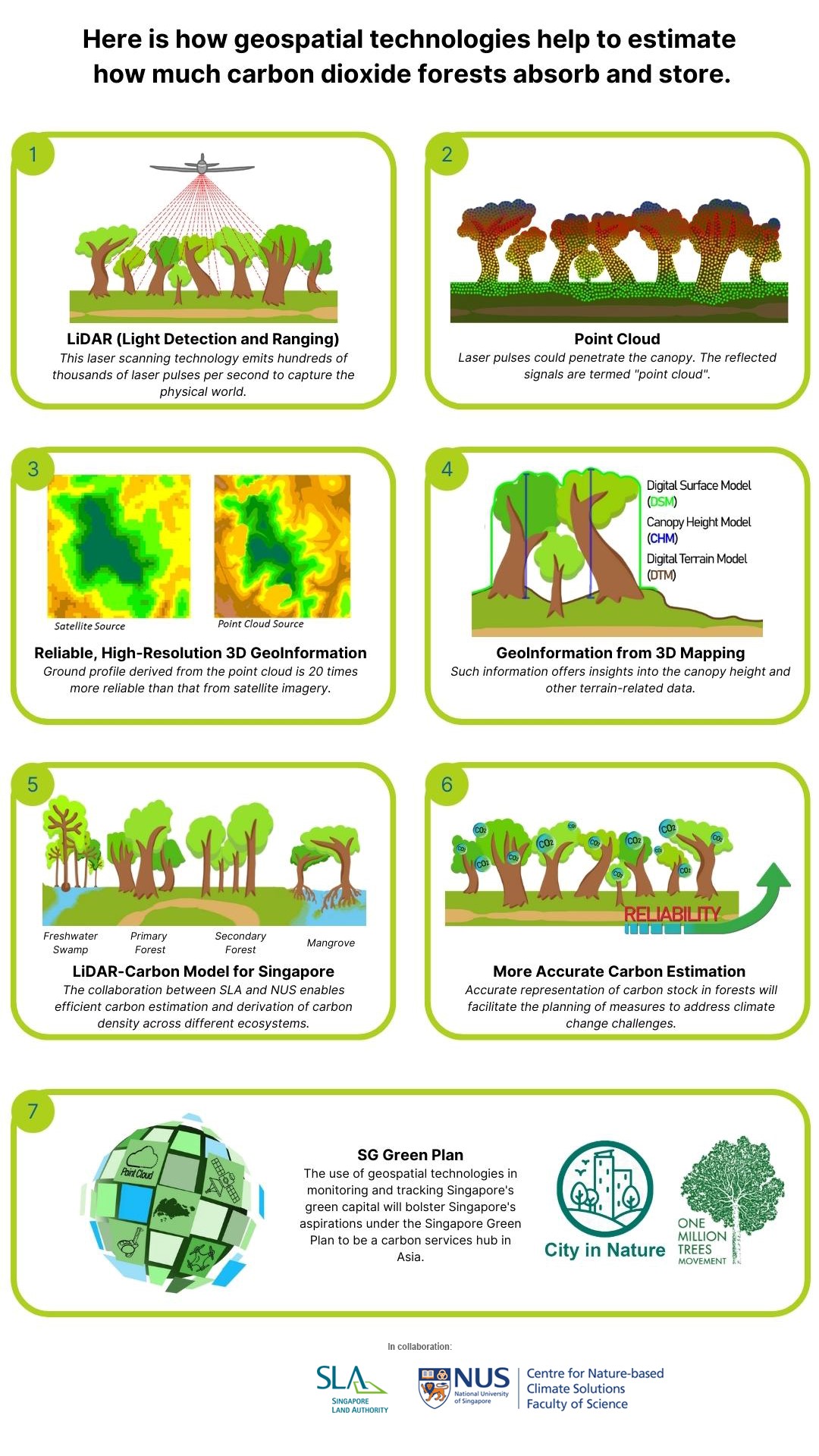
3 The carbon estimation research intends to assess the amount of carbon stored in Singapore’s forests and other ecosystems including primary and secondary forests, mangroves as well as parks and gardens. Current carbon estimation research involves fieldwork to collect data which is laborious. It also relies heavily on the use of satellite images which are not of high resolution in terms of image quality and could affect the accuracy of research findings. Through this collaboration, SLA will share geospatial data gathered from airborne laser scanning (also known as Light Detection and Ranging or LiDAR) as well as high-resolution aerial images with NUS CNCS to supplement the carbon estimation analyses by their researchers. The findings from NUS CNCS’s research will facilitate planning and implementation of protection and restoration activities across ecosystems in Singapore. Please refer to Annex A for an infographic on how geospatial technologies can help in carbon estimation, and Annex B for the scope of the research activities and a photo of the signing ceremony.
4 Mr Low said, “SLA and NUS share the same vision in being part of the solution in tackling climate change challenges. We have been working together to leverage each other’s expertise to support sustainable development efforts in Singapore. There are vast possibilities for the use of geospatial data and technologies which can offer deeper insights into environmental changes. As a “living lab”, this collaboration will bolster Singapore’s aspirations under the Singapore Green Plan to be a carbon services hub in Asia to facilitate carbon trading. It will also pave the way for greater application of SLA’s 3D mapping expertise in NUS’s research activities, combining geospatial technology and climate science.”
5 Professor Sun, said, “This collaboration will contribute and strengthen national carbon estimation efforts in Singapore to provide data and insights to enable strong evidence-based policymaking. Our researchers at NUS CNCS are looking forward to working with SLA to develop better techniques using novel technology to make advancements in carbon estimation across various ecosystems in Singapore to help drive action on climate change.”
=== End ===
Issued by:
Singapore Land Authority
National University of Singapore
6 October 2022
ANNEX A
Forests absorb carbon dioxide from the atmosphere and store it in tree trunks, leaves and roots. Through this process, forests keep our climate stable along with other positive benefits, like safeguarding biodiversity.
ANNEX B
Memorandum of Understanding between Singapore Land Authority (SLA) and National University of Singapore (NUS) Faculty of Science through the NUS Centre for Nature-based Climate Solutions (CNCS)
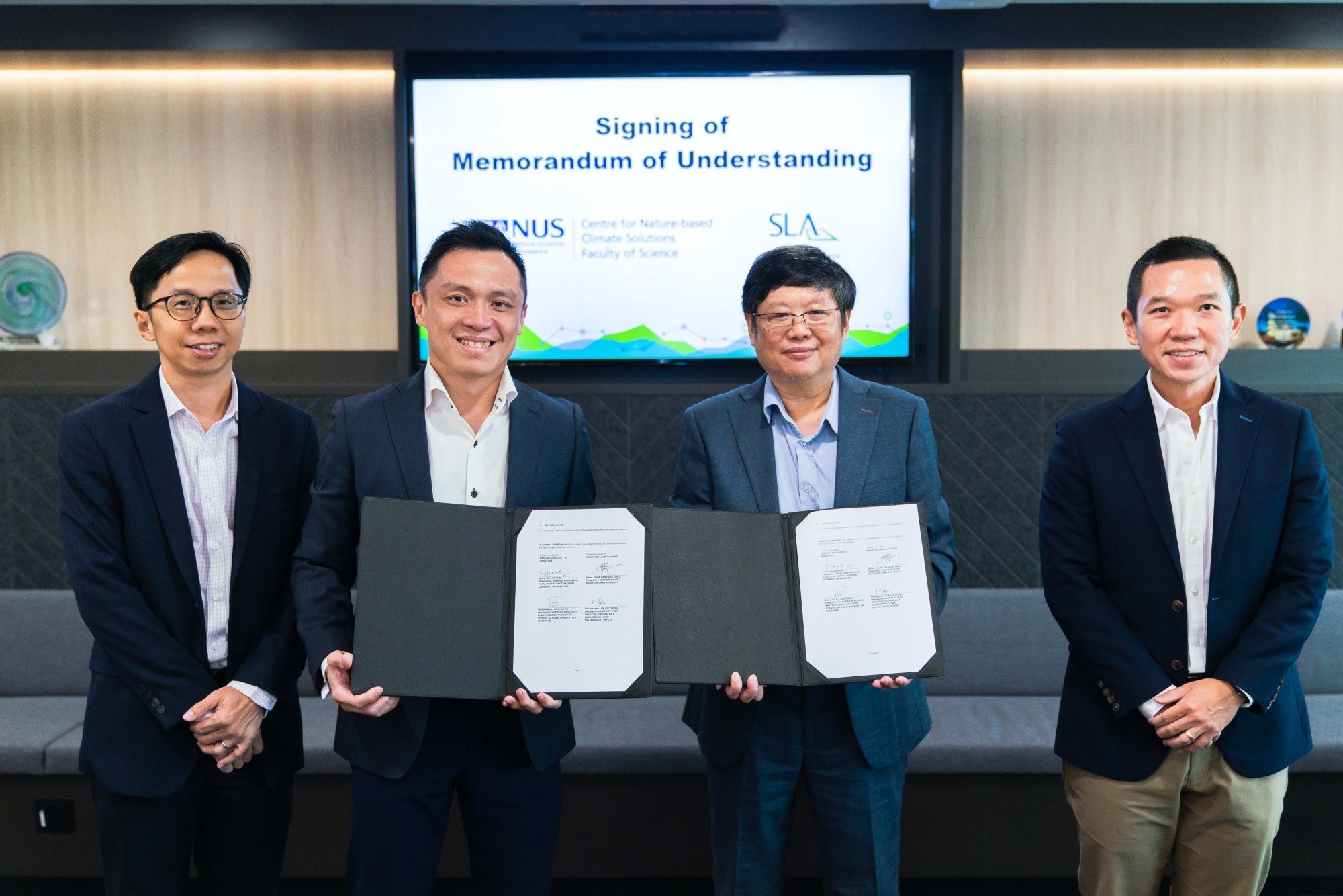
Mr Colin Low (second from left), Chief Executive of Singapore Land Authority (SLA) and Professor Sun Yeneng (second from right), Dean of the National University of Singapore (NUS) Faculty of Science signed a new Memorandum of Understanding (MOU) on 6 October, to leverage geospatial data and technologies for carbon estimation research in Singapore. The MOU signing was witnessed by Mr Sin Lye Chong (extreme left), Assistant Chief Executive (Geospatial & Engagement) and Chief Sustainability Officer, SLA, and Professor Koh Lian Pin (extreme right), Vice Dean (Research), NUS Faculty of Science and Director, Centre for Nature-based Climate Solutions.
Scope of research activities
1. Understand existing carbon stock, carbon sequestration contributions and distribution across various ecosystems (primary and secondary forests, mangroves, parks and gardens etc.) in Singapore;
2. Improve and develop methodological frameworks for green carbon accounting and monitoring approaches;
3. Conduct collaborative research work using novel techniques based on technological advances (e.g. drone mapping and monitoring, Light Detection and Ranging or LiDAR scans, etc.) and publish the findings in suitable scientific journals;
4. Exchange of scientific, academic and technical information and appropriate academic materials and other information of mutual interest (e.g. spatial data, maps, imagery); and
5. Provide broad recommendations on how to increase carbon sequestration for the long term (including ecological habitat restoration, enhancement strategies, and/or targeted species recovery).