

Look for a
lock () or https:// as an added precaution. Share sensitive
information only on official, secure websites.
International and local communities gather at 4th Singapore Geospatial Festival to leverage use of geospatial technologies in accelerating sustainability efforts
- Singapore Land Authority inks new Memorandum of Understanding with Singapore Business Federation to harness the potential of geospatial applications across industries.
- Marks new collaboration with Open Geospatial Consortium, a 500-member non-profit international geospatial standards development organisation, on a pilot initiative aimed at integrating various types of land and marine data to aid coastal protection planning.
Singapore, 4 October 2022 - The 4th Singapore Geospatial Festival 2022 (GeoFest) returns this year in a physical format with a series of talks, panel discussions, workshops and co-located activities aimed at promoting the use of geospatial and mapping innovation. Running from 3 to 7 October 2022, GeoFest is organised by GeoWorks, Singapore’s geospatial industry centre managed and operated by the Singapore Land Authority (SLA). Dr Amy Khor, Senior Minister of State, Ministry of Sustainability and the Environment, and Ministry of Transport, opened the festival with the theme, “A Sustainable Future with Geospatial”, on 4 October 2022. Please refer to Annex A for the welcome remarks by Mr Colin Low, Chief Executive of SLA.
Memorandum of Understanding with Singapore Business Federation (SBF)
2 Recognising that geospatial technologies are an important enabler in Singapore’s Smart Nation journey and sustainability efforts, SLA plays an active role in promoting the use of such technologies. As the National Geospatial Agency, SLA has worked with several partners in leveraging geospatial technologies across diverse sectors, from logistics to real estate to social services. In the latest collaboration, SLA will partner SBF to jointly promote awareness in geospatial technologies and their potential areas of application that are relevant to businesses and related industries under a MOU signed at the festival opening.
3 Signed by Chief Executive of SLA, Mr Colin Low and Chief Executive Officer of SBF, Mr Lam Yi Young on 4 October, the MOU entails the implementation of suitable programmes to help businesses better appreciate how geospatial technologies can improve their current and future operations. Businesses will benefit from SLA’s expertise in geospatial innovations as SLA works with SBF to jointly identify and develop potential geospatial co-innovation projects to find solutions that can address current and future challenges faced by businesses. Please refer to Annex B for the quotes from the signatories and the photo of the signing ceremony.
GeoFest Highlights
Fireside chat for insights into a career in geospatial tech space
4 Of interest in this year’s festival programme is a fireside chat moderated by Dr Nadine Alameh, Chief Executive Officer, Open Geospatial Consortium (OGC), a global non-profit international standards and innovation organisation with a desire to make location information FAIR – Findable, Accessible, Interoperable, and Reusable. Women leaders in the geospatial profession such as Ms Teo Hui Ying, Senior Principal Surveyor of SLA shared their experiences and insights working in the field of geospatial technology and innovation.
Talks and showcases to promote awareness of the uses of geospatial technologies
5 GeoWorks’ members are also part of the line-up for GeoFest with talks and showcases to update on use cases and applications across various sectors. Topics include the use of geospatial data and technologies in the metaverse and Digital Twin Artificial Intelligence, social innovations and in real estate planning.
6 To continue to inculcate geospatial interest and awareness among young professionals and students, activities targeting them such as the annual Regional Geospatial Youth Forum and the Young Geospatial Scientist workshop are also part of the GeoFest.
International geospatial knowledge sharing
7 SLA is also co-hosting the Open Geospatial Consortium 124th Member Meeting at GeoFest this year, bringing together international geospatial experts to discuss efforts to drive geospatial innovations globally. GeoFest attendees can register to attend OGC’s meetings including, but not limited to, the OGC Special Sessions and Asia Forum. At the opening of the festival, Dr Khor announced the collaboration between SLA, the Maritime and Port Authority of Singapore (MPA), and OGC, on a pilot project that will develop prototypes and enhance open standards for integrating various types of land and marine data. The integration of land and marine data will support Singapore’s efforts in planning for coastal protection against the threat of rising sea levels due to climate change. The learning points from this pilot project will be useful for countries which are also working on enhancing their coastal protection. For more details on this collaboration, please refer to Annex C.
8 The line-up of the activities organised during Singapore Geospatial Festival 2022 is available at the event website at https://www.sla.gov.sg/geoworks/programmes/singapore-geospatial-festival.
=== End ===
Issued by:
Singapore Land Authority
4 October 2022
ANNEX A
Welcome Remarks by Mr Colin Low, Chief Executive, Singapore Land Authority at the Joint Opening of the Singapore Geospatial Festival 2022 & the Open Geospatial Consortium Member Meeting at Lifelong Learning Institute on 4 October 2022 (Tuesday)
Dr. Amy Khor, Senior Minister of State for Transport and Senior Minister of State for Sustainability and the Environment,
Dr. Nadine Alameh, Chief Executive Officer, Open Geospatial Consortium,
Mr Lam Yi Young, Chief Executive Officer, Singapore Business Federation,
Captain Muhammad Segar, Assistant Chief Executive, Maritime and Port Authority,
Distinguished guests,
Ladies and Gentlemen,
Good morning.
1. Welcome to the joint opening of the Singapore Geospatial Festival 2022 and the Open Geospatial Consortium Member meeting.
2. As the national geospatial agency, the Singapore Land Authority develops, supports, and promotes the adoption of geospatial information, services, and technologies.
3.
We do this not alone,
but with our partners from the public and private sector. The Singapore
Geospatial Festival, GeoFest in short, manifests this concerted effort. We have
lined up an exciting and broad-based programme filled with co-located industry
events and activities this week. Whether you are an expert or simply curious to
learn more, we welcome you to GeoFest 2022.
A Sustainable Future with Geospatial
4. Some of you might wonder why geospatial is so critical. In an ever-changing world, hot button issues such as climate change have come to the forefront of every nation’s agenda. The United Nations (UN) is spearheading a global movement to encourage sustainability through formulating sustainable development goals (SDGs). Through the SDGs, the UN calls for urgent action in areas such as building sustainable cities and initiating climate action.
5. We align with the UN SDGs by exploring methods through which we can craft a more sustainable future for Singapore. Geospatial, in fact, plays an important role in achieving this objective. Geospatial can and should be a key enabler in our sustainability journey. To give an example, the placement of solar panel on the roof top to tap on clean energy may sound like a simple decision – every building has a roof! But is it truly that simple? Few people know that there are many geospatial parameters, including roof height, surface, facing, etc. that are critical in determining the optimal solar panel placement to derive the maximum amount of solar power. We need geospatial data and technology, solutions, and innovations to help us better tackle climate change challenges.
6. The theme for GeoFest 2022 – ‘A Sustainable Future with Geospatial’ reflects both our concerns regarding sustainability and desire to address them. This week’s events and activities will largely focus on this issue. By tapping on the expert knowledge through talks and workshops, including the Open Geospatial Consortium (OGC) member meeting, we can all learn about, or at least become aware of, how geospatial can help us address sustainability challenges.
Open Geospatial Consortium Member Meeting
7. The OGC has done invaluable work around the globe, spreading the use of geospatial for the greater good. Their decision to hold the Member Meeting here, in conjunction with the GeoFest, spotlights the importance of geospatial not just in Singapore but also in the APAC region.
8. SLA and MPA are honoured to co-host this meeting that sees many OGC members from different parts of the world gather here. Their expertise and experience in geospatial standards and technology will certainly benefit Singapore. In fact, we share a common goal with the OGC – to work towards creating a sustainable future with geospatial. Not just for ourselves, but for our children and future generations.
Closing
9. To build this future, we require collaboration between all sectors. To this end, SLA will be signing two collaboration MOUs this week. One is with the National University of Singapore’s Centre of Nature-based Climate Solutions this Thursday, and another, with the Singapore Business Federation, today. We hope the collaboration among the public sector, the academics, and the business community will help drive the use of geospatial for better climate and business solutions.
10. In closing, I would like to thank our partners who are organising geospatial events in conjunction with GeoFest – ESRI Singapore, Hexagon, the National Super Computing Centre, Nvidia, the Real Estate Developers Association of Singapore, Singapore Science Centre – just to name a few, who all see the importance of making the GeoFest an anchor geospatial industry event in Singapore. We hope this concerted effort will grow in strength and spread the message of the power of geospatial information and technology.
11. Lastly, I hope that you will find the events lined up this week enriching and inspiring. I wish all of you an enjoyable time at GeoFest 2022. Thank you.
ANNEX B
Memorandum of Understanding between Singapore Land Authority (SLA) and Singapore Business Federation (SBF) – Quotes from signatories
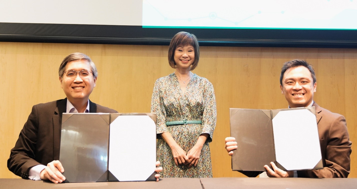 Chief Executive
of Singapore Land Authority, Mr Colin Low (right) and Chief Executive Officer of Singapore
Business Federation, Mr Lam Yi Young (left) signed a new Memorandum of Understanding (MOU) on 4
October, to harness the potential of geospatial applications
across industries. The MOU signing was witnessed by Dr Amy Khor (centre), Senior Minister of State, Ministry of
Sustainability and the Environment, and Ministry of Transport.
Chief Executive
of Singapore Land Authority, Mr Colin Low (right) and Chief Executive Officer of Singapore
Business Federation, Mr Lam Yi Young (left) signed a new Memorandum of Understanding (MOU) on 4
October, to harness the potential of geospatial applications
across industries. The MOU signing was witnessed by Dr Amy Khor (centre), Senior Minister of State, Ministry of
Sustainability and the Environment, and Ministry of Transport.
“SBF is pleased to be collaborating with SLA to help companies better appreciate the use of geospatial technologies and services in their businesses. Companies in sectors such as waste management, logistics, landscaping, retail and F&B, can potentially benefit from the use of such technologies in their operations to improve productivity and reach out to their customers. SBF will partner SLA and other trade associations and chambers (TACs) to share about the solutions companies can adopt or co-develop with solution providers to maximise their business opportunities.”
- Mr Lam Yi Young, Chief Executive Officer of SBF
“SLA is already working with companies which are interested to tap on geospatial data to optimise last-mile deliveries which indirectly reduces carbon footprint by cutting traveling time, or using it in construction to mitigate flood risks. The partnership with SBF will provide a springboard to share such insights with more businesses so that they can start to appreciate geospatial data and technologies and learn to apply them to transform or improve their business operations and service delivery. The MOU with SBF is an important step in that direction. We are excited to work closely with SBF to help our local businesses to think about, and eventually adopt geospatial data and technologies in ways that will benefit them.”
- Mr Colin Low, Chief Executive of SLA
ANNEX C
Pilot project to develop prototypes and enhance open standards for integrating various types of land and marine data
As part of continuous innovation efforts, the Singapore Land Authority (SLA) and the Maritime and Port Authority of Singapore (MPA) will collaborate with the Open Geospatial Consortium (OGC) on a pilot project, known as “the Open Geospatial Consortium - International Hydrographic Organisation - International Standards Organisation Federated Marine Spatial Data Infrastructure (OGC-IHO-ISO FMSDI) Pilot Project Phase V”. The pilot project aims to develop application prototypes and enhance open standards for integrating various types of land and marine data.
Rationale for the collaboration
2 Like many island countries, Singapore faces climate change impacts such as rising sea levels, projected increased frequency and intensity of storm surges and rainfall. The use of relevant technologies and the integration of land and marine data, especially at the coastal zone, is critical to Singapore’s resilience, for instance through proactive planning and decision-making for coastal and port infrastructure protection.
3 Currently, there are various international and national standards being used to record and access land and marine data, as well as cadastral, sensor, and statistical data, with the National Marine Spatial Data Infrastructures like Singapore’s GeoSpace-Sea. Through prototyping, the pilot project will test out how these various standardised data can be applied with technologies such as digital twins and application programming interfaces, to visualise, and if need be, inform the enhancement of existing open standards.
Scope
4 The project will seek to produce a practical definition of digital twins in Singapore’s context and see the development of application prototypes using open standards that can serve as a case study for global implementation in future. The co-development of the open standards for integrating land and marine data will also pave the way to the development of a digital twin that integrates land and sea in Singapore to facilitate coastal protection, marine and coastal spatial planning, critical infrastructure protection and resilience.
5 Captain Muhammad Segar, Assistant Chief Executive (Operations), said, “The ability to integrate land and marine data will better support decision making for coastal and port infrastructure planning and development. MPA is excited to partner SLA and OGC on a pilot to develop open standards for integrating various types of land and marine data and application prototypes based on those standards, including digital twin technologies.”
6 Mr Colin Low, Chief Executive of SLA, said, “Singapore takes climate change seriously and we have seen the global impact of climate change faced by other countries. At SLA, we are supporting the global efforts to address climate change challenges by tapping on geospatial technologies and working with our partners on appropriate solutions. We are happy to partner OGC which is highly regarded for its open standards development work, and MPA which has been playing an important role in environmental protection in this pilot project. Through the project, we hope to build up a more robust repository of land and marine data that will help us in enabling better solutions in protecting our coastlines. Beyond Singapore, the findings from the project will benefit other countries which are also looking at using land and marine data for their coastal protection planning strategies.”
Additional Photos of the Opening of 4th Singapore Geospatial Festival 2022
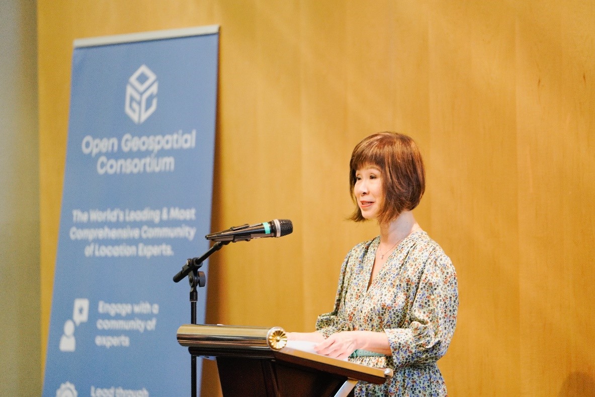 Dr Amy Khor, Senior Minister of
State, Ministry of Sustainability and the Environment, and Ministry of
Transport, delivering the opening speech at the 4th Singapore
Geospatial Festival on 4 October 2022.
Dr Amy Khor, Senior Minister of
State, Ministry of Sustainability and the Environment, and Ministry of
Transport, delivering the opening speech at the 4th Singapore
Geospatial Festival on 4 October 2022.
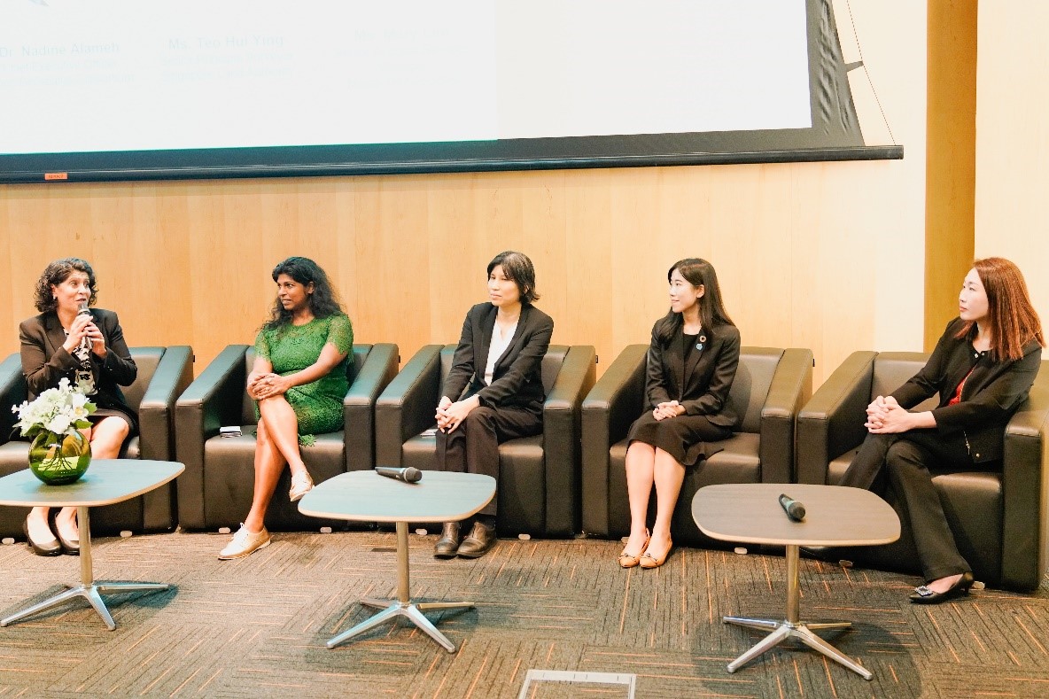 Dr Nadine Alameh (extreme left),
Chief Executive Officer, Open Geospatial Consortium (OGC) moderated a fireside
chat with women leaders in the geospatial profession who shared their
experiences and insights working in the field of geospatial technology and
innovation. The panellists are (from
left) Ms Mani Thiru, Head, Space &
Satellite at Amazon Web Services Asia Pacific; Ms Teo Hui
Ying, Senior Principal Surveyor, Singapore Land Authority; Ms Pearlyn Pang,
Assistant Hydrographer, Maritime and Port Authority of Singapore; Ms Mary Lim,
Senior Account Services Manager, Maxar Technologies.
Dr Nadine Alameh (extreme left),
Chief Executive Officer, Open Geospatial Consortium (OGC) moderated a fireside
chat with women leaders in the geospatial profession who shared their
experiences and insights working in the field of geospatial technology and
innovation. The panellists are (from
left) Ms Mani Thiru, Head, Space &
Satellite at Amazon Web Services Asia Pacific; Ms Teo Hui
Ying, Senior Principal Surveyor, Singapore Land Authority; Ms Pearlyn Pang,
Assistant Hydrographer, Maritime and Port Authority of Singapore; Ms Mary Lim,
Senior Account Services Manager, Maxar Technologies.