Look for a
lock () or https:// as an added precaution. Share sensitive
information only on official, secure websites.
Fact Sheet
About Singapore GeoSpatial Challenge (SGC) 2013
1. The Singapore GeoSpatial Challenge 2013 is organised by the Singapore Land Authority to encourage the adoption of geospatial concepts and technologies, and make use of a gamified geospatial mobile application to help students learn more about Singapore’s heritage and environment. Through this, it hopes to raise awareness of and increase interest in Geospatial Information Systems and Technology (GIST) amongst youths. (Refer to Fact Sheet for the list of participating schools).
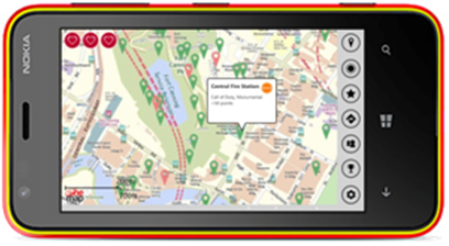
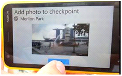
2. To win, student teams will need to gain the most number of points. Teams use a geospatial mobile application, specially developed by Nanyang Polytechnic’s School of Information Technology (SLA’s GIST Academic Partner) to navigate around the civic district and gain points by performing as many check-ins at the locations given as possible. There are 90 locations in total. Some locations contain quizzes which give additional points when answered correctly. The locations include heritage sites, monuments and heritage trees. Particular combinations of caches can help teams unlock up to 16 different achievements, which give further additional points. Four preliminaries were held last week with the finals held today (Refer to Annex B for pictures of devices and preliminaries).
3. More than $20,000 worth of prizes will be given out including mobile phones and books on GIST. Five teams will also have a chance to personally plant a tree if they obtain the “Eco-Warrior” achievement, which can be unlocked by checking-in at 14 different heritage trees in Singapore.
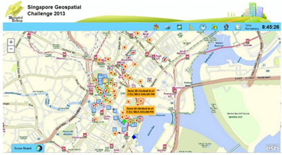
4. A live dashboard on site allows the audience to follow the progress of and analyse the race in real time. The dashboard is able to:
| a. | Display the locations of all teams and their
routes |
| b. | Compare scores and relative standing of teams |
| c. | Track speed and progress of teams |
| d. | Highlight status of checkpoints |
| e. | Analyse areas of high activity through a heat map |
| f. | Incorporate live tweets from the participants and the public |
5. SGC 2013 is a collaboration between SLA, the National Heritage Board (NHB), National Parks Board (NParks) and Preservation of Monuments Board (PMB). Organised for Pre-University and Secondary School students, the competition is supported by the Ministry of Education, the United Nations Initiative on Global Geospatial Information Management (*UNGGIM) and the NUS Geographical Society.
6. The competition has received strong industry support from Esri Singapore, Microsoft Singapore, Starhub and Nokia.
Singapore Geospatial Scholarship
7. The Singapore Geospatial Scholarship is a multi-agency collaboration among statutory boards from different ministries to offer local and overseas geospatial scholarships for undergraduate and postgraduate studies.
8. The objectives of the Singapore Geospatial Scholarship are to:
|
9. We are currently working out the details of the Singapore Geospatial Scholarship with the interested agencies. More information on the scholarship will be made available at the end of the year.
United Nations Initiative on Global Geospatial Information Management (UNGGIM)
10. UNGGIM is an inter-Governmental mechanism spearheaded by the United Nations, which seeks to set the agenda for the development of global geospatial information and to promote its use to address key global challenges, such as in climate change and sustainable development
11. Established in Oct 2011, the UNGGIM and its Committee of Experts work with Governments to improve policy, institutional arrangements and legal frameworks to facilitate the development of effective strategies to build geospatial capacity in Member States.
12. This global initiative enjoys strong support from the international community. For example, the first High Level Forum was attended by 350 participants from 90 Member States, 22 United Nations representatives and 37 International Organizations and the Private Sector. A record number of 8 Ministers - the highest number for any UN High Level Forums, attended the Forum to voice support for the role of geospatial information in policy and national development.
13. Singapore participates actively in UN-GGIM activities and made presentations at its 2nd High Level Forum held in Feb 2013, Doha.
14. The Singapore delegation was led by Vincent Hoong, Chief Executive, SLA.
Annex A: List of participating schools
Secondary Schools
| S/N | SCHOOL NAME |
|---|---|
| 1. | BEATTY SECONDARY SCHOOL |
| 2. | BOWEN SECONDARY SCHOOL |
| 3. | DUNEARN SECONDARY SCHOOL |
| 4. | CANBERRA SECONDARY SCHOOL |
| 5. | CEDAR GIRLS' SECONDARY SCHOOL |
| 6. | CHIJ ST NICHOLAS GIRLS SCHOOL |
| 7. | CHRIST CHURCH SECONDARY SCHOOL |
| 8. | CHUNG CHENG HIGH SCHOOL (MAIN) |
| 9. | EVERGREEN SECONDARY SCHOOL |
| 10. | FUCHUN SECONDARY SCHOOL |
| 11. | GAN ENG SENG SCHOOL |
| 12. | JUYING SECONDARY SCHOOL |
| 13. | NAN HUA HIGH SCHOOL |
| 14. | NORTHBROOKS SECONDARY SCHOOL |
| 15. | NORTHLAND SECONDARY SCHOOL |
| 16. | NUS HIGH SCHOOL |
| 17. | PEI HWA SECONDARY SCHOOL |
| 18. | PUNGGOL SECONDARY SCHOOL |
| 19. | SERANGOON GARDEN SECONDARY SCHOOL |
| 20. | SIGLAP SECONDARY SCHOOL |
| 21. | ST MARGARET'S SECONDARY SCHOOL |
| 22. | TANJONG KATONG SECONDARY SCHOOL |
| 23. | TEMASEK SECONDARY SCHOOL |
| 24. | YUSOF ISHAK SECONDARY SCHOOL |
Junior Colleges and Institutes
| S/N | SCHOOL NAME |
|---|---|
| 25. | ANGLO-CHINESE JUNIOR COLLEGE |
| 26. | CATHOLIC JUNIOR COLLEGE |
| 27. | HWA CHONG INSTITUTION |
| 28. | MERIDAN JUNIOR COLLEGE |
| 29. | MILLENNIA INSTITUTE |
| 30. | NANYANG JUNIOR COLLEGE |
| 31. | NATIONAL JUNIOR COLLEGE |
| 32. | NUS HIGH SCHOOL |
| 33. | PIONEER JUNIOR COLLEGE |
| 34. | RAFFLES INSTITUTION |
| 35. | ST ANDREW'S JUNIOR COLLEGE |
| 36. | TAMPINES JUNIOR COLLEGE |
| 37. | TEMASEK JUNIOR COLLEGE |
Annex B: Pictures of devices and preliminaries
1. Using the geospatial mobile application to locate checkpoints
2. Using the geospatial mobile application to check-in
3. Following the progress of the game via the dashboard
4. Students looking for their next checkpoint