|
#SgGeoWeek: SLA GeoWorks’ geospatial celebration - the 2nd Singapore Geospatial Week goes virtual and regional in 2020
In SLA’s Acting Chief Executive, Mr Simon Ong’s welcome speech, he said: “When we first mooted the idea of creating a Singapore Geospatial Week a year and a half ago, we did not anticipate we would get such overwhelming response from the geospatial industry. We thought it was a good occasion to celebrate and encourage the use of geospatial technology and information supporting our Smart City initiatives. We had imagined a limited one-week event, attended by a selection of experts and attended by a small group of geospatial enthusiasts.
“We did not imagine that in just our second year, we will be organising an expanded two-week programme, speaking to an international audience, playing host to over 60 webinars, and having over 80 speakers and panellists from around the region contribute their time, knowledge and expertise to our event. I am deeply humbled by the industry’s response and would like to thank everyone here today who has contributed to the success of Singapore Geospatial Week+ 2020.”
SLA’s commitment to spur geospatial growth
“SLA, as the national geospatial agency for Singapore, has always advocated the use of geospatial technology and information, to improve business processes and decision-making, and to bring geospatial organisations together for innovation. And we will continue to stress this need and take pro-active steps to encourage the adoption of geospatial technology across multiple industries – whether it’s in Build and Infrastructure, Mobility and Logistics, Real Estate and Retail, or Urban and Environment.
“…[and] Singapore Geospatial Week is our commitment to that aim, and we hope the activities organised over these two weeks will provide Interest, Excitement and Inspiration for the next generation of entrepreneurs and leaders to use geospatial technology for the good of business and the community alike.”
Mr Ong also said that he hope that the event will encourage other organisations to consider holding their own geospatial days in Singapore or elsewhere in the world, so that everyone becomes aware and familiar with the power that geospatial technology can bring. “And perhaps one day in the future, we can look back to 2020 and see Singapore Geospatial Week as the seed that would eventually grow to become the premier regional or global geospatial celebration. We look forward to that day,” added Mr Ong.
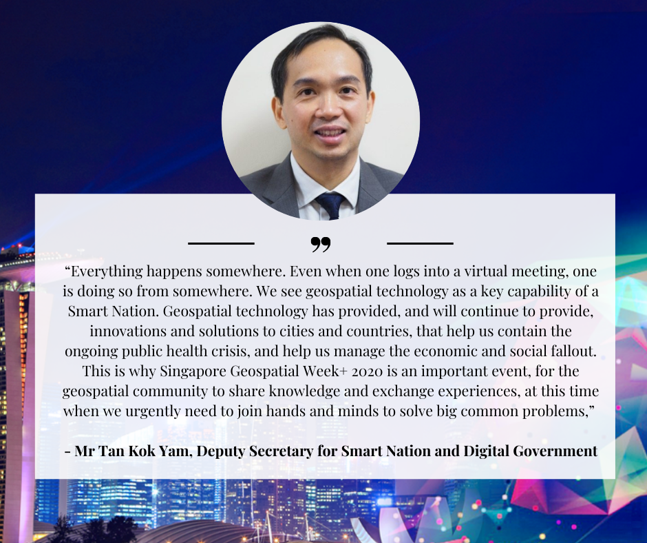
“Everything happens somewhere. Even when one logs into a virtual meeting, one is doing so from somewhere. We see geospatial technology as a key capability of a Smart Nation. Geospatial technology has provided, and will continue to provide, innovations and solutions to cities and countries, that help us contain the ongoing public health crisis, and help us manage the economic and social fallout. This is why Singapore Geospatial Week+ 2020 is an important event, for the geospatial community to share knowledge and exchange experiences, at this time when we urgently need to join hands and minds to solve big common problems,” said Deputy Secretary for Smart Nation and Digital Government, Tan Kok Yam.
Launch of OneMap3D Beta
The Beta version of OneMap3D, Singapore Land Authority (SLA)’s open-source 3D city map portal was also launched at #SgGeoWeek. OM3D Beta is now available for trial by businesses, developers and members of the public. For more information, visit www.OneMap3D.gov.sg.
Watch the GeoWorks OneMap3D Beta Launch video:
Watch the ChannelNewsAsia coverage for OM3D Beta launch
Watch the OneMap3D Beta event video:
Other highlights:
Covid-19-themed webinars: Managing safety for the community
A spotlight feature for Singapore Geospatial Week+ 2020 is the Covid-19 webinar series, showcasing the use of geospatial solutions to better manage public safety efforts in a pandemic. Led by industry speakers including GeoWorks’ GeoTechs - CITYDATA, TNO, and GeoPartner Grab amongst others, the Covid-19 webinar series will highlight the use of how geospatial technologies are leveraged in an urban environment and integrated into a new normal for the community.
“The importance of geospatial cannot be emphasised more, especially in today’s environment. For example, the current Covid-19 pandemic has driven the need for businesses to use geospatial information and location-based data to develop new crowd management applications that takes into consideration safe distancing measures, so that the public can make informed decisions to protect themselves. Geospatial can also be used as a collaborative tool when responding to the pandemic. By combining different data types and technologies based on location, businesses can understand people movement patterns, and deploy the necessary resources to protect their staff and the community,” said Mr Simon Ong, SLA’s Acting Chief Executive.
International knowledge sharing
GeoInnovation from Around the World is introduced as a dialogue segment to promote geospatial sharing across borders for industry professionals. Hosted by GeoWorks’ GeoCommunity partners from around the globe, this knowledge sharing initiative will be led by start-ups and agencies from around the world including Australia, Finland, Japan, United Kingdom and the United States to build geospatial interest and expertise sharing.
Geospatial data and analytics in public sector
Geospatial data and analytics have also served as a platform for government agencies and city planners. The public sector sharing segment will draw focus on the use of geospatial technologies to achieve better governance and how it has been adopted by public agencies for land and sea planning, development of liveable cities, and even for urban trees and greenery management.
SLA has collaborated with the National Parks Board on the use of location- based information to drive efficiency in the management of green spaces. Leveraging on the OneMap base map as a visualisation tool, maintenance information is streamlined on a single platform to identify gaps and minimise overlaps in service delivery. Featuring updated counts and location information of trees to be maintained, this platform is also used for service and operation planning.
![tiered logo2305843009219521192].png](/qql/slot/u148/News & Media/News/2020/Sep/2nd SG Geospatial Wk virtual/tiered logo2305843009219521192.png)